OverviewNearbyReviewsWin PrizesRecommended
Share to
Sugarloaf
慶良間チージ(安里52高地・シュガーローフ)1.9
 based on 6 reviews
Open year round, 24/7
Address:
1 Chome-6 Omoromachi, Naha, Okinawa 900-0006, JapanMap
What travelers say:

See all 5 photos
Recommendations Near Sugarloaf
Sugarloaf Reviews: Insider Insights and Visitor Experiences
Write a Review
 Trip.com
 (6 Reviews)TripAdvisor6 Reviews
You Might Also Like
Shuri Castle
6.1
4.6/5177 Reviews
From BRL 13.73
Shurijo Castle
6.1
4.5/5793 Reviews
From BRL 13.73
Okinawa Prefectural Museum & Art Museum
5.2
4.5/5155 Reviews
From BRL 13.73

Ryukyu Mura
5.8
4.4/5303 Reviews
From BRL 51.49
Nearby Attractions
Kokusai-dori | Shuri Castle | Shurijo Castle | Naminoue Shrine | Okinawa Prefectural Museum & Art Museum | Naminoue Beach | West Marine-Underwater Sightseeing Tour | Naha City Makishi Public Market | Fukushuen | Diving In Kerama Shotō National Park | Former Japanese Navy Underground Headquarters | Shintoshin | American Village | Ryukyu Mura | Tsuboya Yachimun Street | Okinawa Zoo & Museum | Ounoyama Park | Okinawa World | Shikinaen | Okinawa Marine Gliding | Heiwa Dori | Okinawa Prefecture Government Office | Southeast Botanical Gardens | Shijo Hon-dori | Shureimon | 那覇国際通り(なはこくさいとおり) | Tamaudun | Kokusaidori Yataimura | Kinjo Stone Road | Rikkarikka-yu
Popular Types of Attractions in Naha
Parks | City Parks | Aquariums | Zoos | Nature | Beaches | Attractions | Islands/Peninsulas | Architecture & Landmarks | Monuments | Observation Decks | Featured Neighborhoods | Historic Sites | Historical Sites | Castles | Cemeteries | Popular Spots | Outdoor Sports | Water Sports | Golf Courses | Hiking | Sightseeing Tours | Water Activities | Other Sightseeing Tours | Aerial Tours | Exhibition Centers | Museums | Planetariums | Art Museums | Lifestyle
Popular Restaurants in Naha
Yakiniku MotobuFarm - Okinawa | Okinawa Tonkatsu Shokudo Shimabutaya Kumoji | Fontaine | Grand Castle Cafe and Dining | Shunten | Steam Dining Shimabutaya | Yakiniku Gokujogyu | ALL DAY DINING vision&emotion | Nihonryori Fuji Daburutsuri by Hirutonnahashurijoh | Hanagasa Shokudo | Okinawa Dining Hateruma | Airport Restaurant | LaLa Primo, Shintoshin | Gyu-Kaku | Gyuu Ou | yotsutake | Sakurazaka | Steakhouse 88 Kokusaistreet | Tenryu | Yakiniku Hana | Yunangi | Mion | 我那覇豚肉店(カフーナ旭橋) | Pork Tamago Onigiri Honten | Wafutei Naha Main Place | Kaki Goya Naha Sakurazaka | 37ステーキハウス&バー那覇 | Kobe Bar Nakanaka | Shuri Soba | Sennichi
Popular Destinations
Guiyang Travel | Seoul Travel | Martinsburg Travel | Sydney Travel | Indianapolis Travel | Hong Kong Travel | Vienna Travel | Phoenix Travel | Tagaytay Travel | Boston Travel | Canakkale Travel | Bukit Mertajam Travel | Fort Knox Travel | Wanning Travel | Riyadh Travel | Iowa City Travel | Bohol Island Travel | Pescara Travel | Hempstead Travel | Weihai Travel | Grayslake Travel | Hapeville Travel | Kettering Travel | Barrow Travel | Cholula Travel | Mougins Travel | Zanda Travel | Versailles Travel | Warren County Travel | Jian'ou Travel
Recommended Attractions at Popular Destinations
Bangkok attraction near me | Manila attraction near me | Tokyo attraction near me | Hong Kong attraction near me | Seoul attraction near me | Taipei attraction near me | Los Angeles attraction near me | Shanghai attraction near me | New York attraction near me | Kuala Lumpur attraction near me | Shenzhen attraction near me | Osaka attraction near me | London attraction near me | Singapore attraction near me | Guangzhou attraction near me | San Francisco attraction near me | Beijing attraction near me | Macau attraction near me | Bali attraction near me | Paris attraction near me | Jakarta attraction near me | Ho Chi Minh City attraction near me | Orlando attraction near me | Toronto attraction near me | Phuket attraction near me | Chicago attraction near me | Cebu attraction near me | Istanbul attraction near me | Seattle attraction near me | Dallas attraction near me
Popular Ranked Lists
Popular Family-friendly Attractions Near Ergun | Top 4 Premium Hotels in Perth and Kinross | Top 12 Local Restaurants in Phnom Penh | Popular Family-friendly Attractions Near Xing'an County | Popular Premium Hotels in Bang Sao Thong District | Top 4 Bars in Naha | Popular Family-friendly Attractions Near Lushan | Top 10 Local Restaurants in Perth | Popular Family-friendly Attractions Near Nancha County | Top 3 Premium Hotels in Kizilagac | Popular Premium Hotels Near Bilaspur | Top 10 Bars in Amman | Top 8 Local Restaurants in Nadi | Top 10 Jiangzhe Cuisine Restaurants in Anji | Top 20 Local Restaurants in Cairo | Popular Family-friendly Attractions Near Guannan | Popular Luxury Hotels in Brussels-Capital Region | Popular Luxury Hotels Near Bad Nauheim | Top 4 Premium Hotels in Vung Tau | Popular Family-friendly Attractions Near Zhangye | Popular Family-friendly Attractions Near Fuchuan | Popular Family-friendly Attractions Near Fushun County | Popular Family-friendly Attractions Near Shimian | Popular Luxury Hotels Near Ajkai | Top 19 Local Restaurants in Da Nang | Top 10 Local Restaurants in Stockholm | Popular Family-friendly Attractions Near Dushan | Top 5 Bars in Hua Hin | Popular Premium Hotels Near Ballito | Global Synthesis - Trip.Trends
Trending Travelogues
Popular Trip Moments
Must-Visit in Okinawa: Naminoue Shrine | The Hilton Yilin Hotel built on the mountain in Naha Shuri Castle | Okinawa Souvenir: The Salt Specialty Store. | Hot Springs in the Bustling City! Okinawa Naha Sansui Hotel. | I enjoy the freedom of seafood at the seafood market in Okinawa | Naha city walk, you can't finish walking even if you break your legs | Jack's Steakhouse, an Old-Fashioned Steakhouse in Naha, Okinawa, Japan | Naha's Longest Shopping Street! Kokusai Dori is a great place to shop, eat, drink, play, and take photos | 【Okinawa】The door to an unexpectedly cute and stylish cafe. | Visit of Shuri Castle 🏰🇯🇵 | Experienced Hotel Collective in Okinawa | Shikinaen Garden | [Okinawa] If you're looking for a stylish hotel stay in Naha, this is the place. | A person does not rent a car, and plays all over Okinawa in two days on the weekend | Okinawa Prefectural Museum | Sonohiya Take Ontake Sekimon | 【Okinawa】A retro vibe flows through the cafe "Coffee Shop Laramie". | 【Scenery You Can Only See Now】Shuri Castle | One of the 8 shinto shrine in Okinawa | Okinawa Shuri Castle | 【Okinawa】A Garden in Naha City That Feels Like China. | Okinawa Seafood Heaven | Infinite experiences in the infinity pool | the rise of Okinawa Shuri Castle | Chasing the Spectacular Northern Lights: My Experience of Witnessing Aurora Borealis at Level 8 in | #okinawatrip | Experienced south west grand hotel Okinawa | Experienced Prostyle Terrace Naha | Experienced Hewit Resort Naha in Okinawa
Popular Travel Types
More Things To Do in Naha
Japan eSIM Day Pass/Data Package (QR Code) | [Japan] DOCOMO eSIM Data Package QR code | Okinawa + Kouri Island + Cape Manza Day Tour [Churaumi Aquarium/Tropical Botanical Garden/American Village/Chinese, English, Korean, Japanese Audio Guide] | Okinawa Tokutoku Pass | KERAMA Island Snorkeling and Parasailing Experience from Naha | Japan Okinawa Churaumi Aquarium + Cape Manza + Nakijin Castle Day Tour [Lunch included / Ocean Expo Park / Okinawa North Comfortable Bus tours/ World Heritage Sightseeing] | Traditional Okinawan Costume Experience | Japan Okinawa Sightseeing Bus World Cultural Kingdom/Churaumi Aquarium including lunch Japanese speaking tour guide | Former Navy HQ Headquarters Fees for visiting historical buildings for war and peace | Okinawa Island Custom Full Day Tour | Enchanted Okinawa: A Romantic Journey Through Shuri | Okinawa Churaumi Aquarium + Cape Manza Day Tour [Underwater Observation Boat + Bise Fukugi Forest + American Village / Chinese and English Guide / Bus tours] | Okinawa, Japan + Manzamo + Gogashi Palace (Onna Branch) one-day tour [Ryukyu Village/Churaumi Aquarium/Kouri/American Village/Tropical Botanical Garden/Including Chinese and English guide] | Naha Full-Day Private Tour with Government Licensed Guide | Okinawa Island Custom Part Day Tour By Private Vehicle | Okinawa Naha Yukata & Kimono Rental Experience | Gyokusen Cave + Cape Chinen Park + Senaga Island + American Village + Manzamo + Kouri Island + Okinawa Churaumi Aquarium One-Day Tour [Okinawa Custom Chartered Vehicle| Cruise Ship Pickup Available] | Karate History Tour in Okinawa | Explore Okinawa (Naha, Churaumi Aquarium, Kouri) using Private Hiace Van | Sakaemachi Market Bar Hopping Tour | Okinawa Explorer: Shrines, Markets & Vibrant Streets | Airport Transfer! Naha Airport (OKA) to Center of Naha | Japanese traditional costumes "Kimono" "Yukata" "Ryuso" "Photography course << hair set & point makeup & dressing & photography >> | Explore Okinawa with Private Alphard Car Hire with Simple English Driver | Private Photo Session with a Local Photographer in Okinawa | Airport Transfer! Center of Naha to Naha Airport (OKA) | one-day tour to Tokashiki Island in Okinawa Prefecture, Japan [official ship (excluding Boat Ticket) + island transfer + beach with meals + snorkeling/ diving] | Vacation Photographer in Okinawa | Explore Okinawa with Private Lexus Car Hire with Simple English Driver | Trip.SIM Japan, South Korea, Macau, Taiwan and many places in Asia + Australia and New Zealand 4G travel data roaming phone network card 4 days/7 days
About
Payment Methods
Our Partners
Copyright © 2024 Trip.com Travel Singapore Pte. Ltd. All rights reserved
Site Operator: Trip.com Travel Singapore Pte. Ltd.
Site Operator: Trip.com Travel Singapore Pte. Ltd.
Nothing.
I went shopping with my family to Naha Shintoshin and found a staircase while walking around, so I went up. Then, there was a structure that looked like an observatory and a bulletin that indicated that this place was a battlefield. The reason why it looked like an observatory was that even if I went up, I couldn't see anything because I was surrounded by buildings. I've heard that the new city center was a place where former 々 U.S. military houses spread, but I didn't know it was a battlefield. No, Okinawa is full of battlefields ...
I can't find any trace.
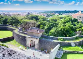
It is a hill that is extremely high in the plateau, which is fairly flat, but even if you actually look at it, it seems that you do not know if it is naturally high or artificially raised. Other highlands that should have been nearby are no trace.
Chongyu の excited
Located in the new city center, there are no remains or traces of those days due to redevelopment. Also, even traces are not seen in half moon. It's just a hill now. There are many cases where there is no information board or it is not written on the map, so it is recommended to go while looking at the Google Maps. Since there is no private parking lot, I used a coin parking nearby. You can only go to the top on foot. I think it's easy to understand the geographical relationship when you go here and then go to Shuri Castle. The explanation board is shallow with the Okinawa war site specification ...
We must not forget the tragedy of Okinawa.
In 1945, the U. s.military landed in Okinawa after a fierce battle against Maeda highlands (Hakuso Cape Ridge) in URASOE, and came to Naha, the capital. The offensive and defense at the hill of Keirama Chiji (US side name = sugar loaf) has killed a little less than 2700 people in the U. s.military alone, and more than 1,000 people have become crazy. It is said that the Japanese army cannot identify the number of people killed in the battle here. Thanks to you, we are now living in peace. 70 years ago this place was hell ...
A few battle sites in Naha city
It is one of the few battle sites in Naha City, which can be walked from Omoromachi Station. Get off the station and walk, and it's on the other side of the big road, so it's a little far, but walk to the intersection with a signal. Go up the stairs in the photo, by the way, there is no guide version at the entrance of the stairs. On the hill there is a guide version that introduces the location. There was certainly a battlefield here. If you have time, let's go.