OverviewBookNearbyReviewsWin PrizesRecommended
Share to
Deception Pass State Park
2.6
5 Reviews
 based on 1434 reviews
Recommended sightseeing time:2-3 hour
Address:
5175 N State Hwy 20, Oak Harbor, Whidbey Island, WA 98277Map
Phone+1 360-675-2417
What travelers say:
The scenery of the park is very good. There are mountains and waters here, the sea is clear, and the surrounding scenery is quite beautiful. The most important thing is that there are relatively few tourists here and you can enjoy the scenery quietly.
More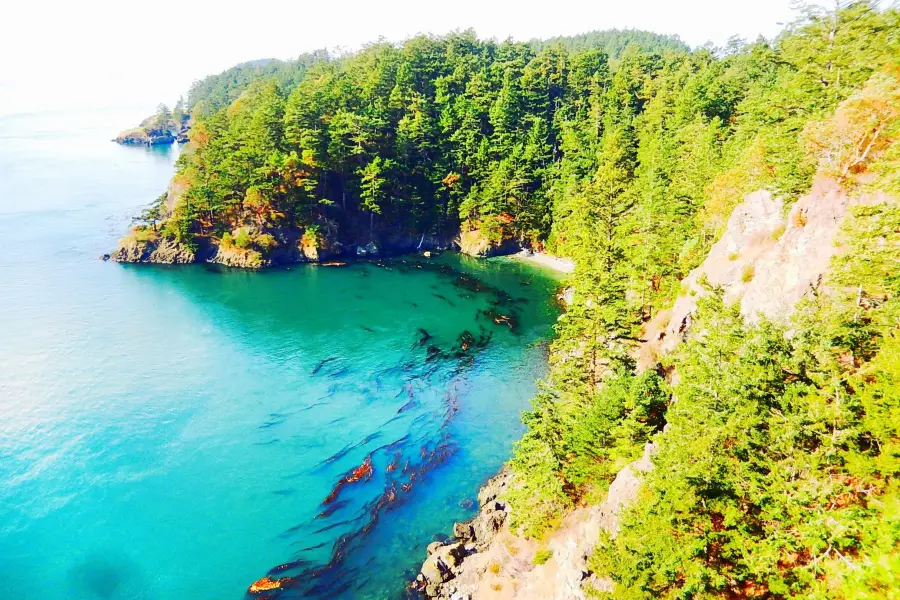
See all 6 photos
Deception Pass State Park Highlights: Must-See Features and Attractions
Some information may have been translated by Google Translate
The crown jewel of Washinton State parks, the trail offers great views tons of trails, fishing, boating and camping. There's also a lovely beach for kite flying, reading or picknicking.
Recommendations Near Deception Pass State Park
Deception Pass State Park Reviews: Insider Insights and Visitor Experiences
Some reviews may have been translated by Google TranslateWrite a Review
 (5 Reviews)Trip.com
 (1,434 Reviews)TripAdvisor
/5
Outstanding ReviewsAll (5)
Latest
With Photos (4)
Positive Reviews (3)
You Might Also Like
Argosy Cruises - Seattle Waterfront
3.7
4/53 Reviews
From €38.40
Argosy Cruises - Lake Union
3.0
No reviews yet
From €54.13
City Sightseeing Seattle
2.0
No reviews yet
From €46.70
Nearby Attractions
Fort Casey State Park | Blue Fox Drive-In Theatre | Fort Ebey State Park | Camano Island State Park | Windjammer Park | Cama Beach Historical State Park | Ebey's Landing | Admiralty Head Lighthouse | Fort Nugent Park | Double Bluff County Park | Fort Casey | Joseph Whidbey State Park | Canopy Tours NW - Zipline Tour, Team Building Challenge Course | West Beach County Park | Oak Bowl & Mario's Pizza | South Whidbey State Park | Bluff Trail | Meerkerk Gardens | Freeland Park | Planet Fitness | Flintstone Park | Freedom Park | Cliffside RV Park | Whidbey Island Kayaking | Libbey Beach Park | Ala Spit County Park | Deception Pass State Park Administration Offices | English Boom Trail County Park | Hastie Lake County Park | Clyde Theatre
Popular Types of Attractions in Island County
Parks | City Parks | Zoos | Botanical Gardens | Outdoor Sports | Hiking | Golf Courses | Water Sports | Religious Sites | Churches and Cathedrals | Other Places of Worship | Temples | Exhibition Centers | Museums | Art Museums | Art Galleries | Nature | National Parks | Lakes | Beaches | Lifestyle | Libraries | Spas | Entertainment Centers | Architecture & Landmarks | Gardens | Featured Neighborhoods | Modern Architecture | Traditional/Cultural Experiences | Wineries/Distilleries
Popular Restaurants in Island County
Toppins Frozen Yogurt | Front Street Grill | El Cazador | Toby's Tavern | Wendy's | Whidbey Island Bagel Factory | BBQ Joint | Rockaway Bar and Grill | Cama Beach Cafe | Shipwreck Coffee | Penn Cove Brewing Co. - Coupeville Brewery & Taproom | Useless Bay Coffee Company | Jack in the Box | Kara's Kitchen at Elger Bay | China City | 1-2-3 Thai Food | Applebee's | Dairy Queen | Pizza factory | Alfy's Pizza | Louie-G's Pizza | Seabolts Smokehouse | Island Cafe | Whidbey Coffee | Sweet Rice Thai Cuisine | Flyer's | Jumbo Burrito | Pickles Deli | Jasmin Thai Express | Honeymoon Bay Coffee Roasters
Popular Destinations
Boracay Island Travel | Cameron Highlands Travel | Jeju Travel | Antigo Travel | Myrtle Beach Travel | Anaheim Travel | Krabi Travel | Urumqi Travel | Kauai Travel | West Des Moines Travel | Effingham Travel | Columbus Travel | Baguio Travel | Yankton Travel | Leshan Travel | Ebina Travel | Batam Travel | Rogers City Travel | Yunnan Travel | Meiringen Travel | Cellole Travel | Valdivia Province Travel | Hakusan Travel | Estrela Travel | Warsaw Travel | Hanzhong Travel | Tolland County Travel | Kyaukse Travel | Herzogtum Lauenburg Travel
Recommended Attractions at Popular Destinations
Bangkok attraction near me | Manila attraction near me | Tokyo attraction near me | Taipei attraction near me | Hong Kong attraction near me | Seoul attraction near me | Los Angeles attraction near me | New York attraction near me | Shanghai attraction near me | Kuala Lumpur attraction near me | Shenzhen attraction near me | Osaka attraction near me | London attraction near me | Singapore attraction near me | Guangzhou attraction near me | San Francisco attraction near me | Beijing attraction near me | Macau attraction near me | Bali attraction near me | Paris attraction near me | Jakarta attraction near me | Ho Chi Minh City attraction near me | Orlando attraction near me | Phuket attraction near me | Chicago attraction near me | Toronto attraction near me | Cebu attraction near me | Istanbul attraction near me | Seattle attraction near me | Dallas attraction near me
Popular Ranked Lists
Popular Family-friendly Attractions Near Taibus Banner | Popular Family-friendly Attractions Near Rizhao | Top 16 Luxury Hotels in Hawaii | Top 15 Local Restaurants in Langkawi | Top 3 Premium Hotels in Koh Lanta | Top 18 Local Restaurants in Santorini | Popular Family-friendly Attractions Near Wuhe | Popular Family-friendly Attractions Near Lingchuan | Popular Luxury Hotels Near Ma'in | Popular Family-friendly Attractions Near Taizhou | Top 8 Bars in Cape Town | Popular Luxury Hotels Near Toyama | Popular Family-friendly Attractions Near Wulian | Popular Family-friendly Attractions Near Duolun | Popular Luxury Hotels in Sal | Popular Family-friendly Attractions Near Zhuozhou | Popular Premium Hotels in Iasi | Popular Family-friendly Attractions Near Manas County | Top 5 Bars in Adelaide | Popular Family-friendly Attractions Near Mengla | Top 15 Local Restaurants in Doha | Top 20 Local Restaurants in Hefei | Top 3 Premium Hotels in Ostuni | Top 15 Local Restaurants in Sydney | Popular Luxury Hotels Near Urubamba | Popular Family-friendly Attractions Near Fengcheng | Top 12 Local Restaurants in Yangon | Popular Luxury Hotels Near Playa Blanca | Popular Family-friendly Attractions Near Hualong | Global Synthesis - Trip.Trends
More Things To Do in Island County
Outdoor Rock Climbing Beginner or Intermediate at Mt Erie | Tree Canopy Climbing on Lopez Island | Sunset Canopy Climb on Lopez Island | Kayaking in Deception Pass State Park | Tulip Festival at Skagit Valley ,La Conner and Deception Pass | TULIP Festival @ Skagit Valley, La Conner & Deception Pass in SUV | Whidbey Island Deception Pass Private SUV Tour | Whidbey Island and Deception Pass - Private Luxury Day Tour with Lunch | Deception Pass Bridge Island Tour from Seattle | USA·Canada eSIM|Unlimited 4G High Speed Data | USA eSIM 5G high-speed network QR code | The Museum of Flight Entrance Ticket | Global (66 Countries) eSIM Data Package (QR Code) | Global multi-region A series eSIM|High-speed data, travel and business Internet access, optional unlimited data, optional days, QR code | Seattle CityPass | eSIM H series in multiple regions around the world | High-speed Traffic for tourism and business Internet access, unlimited Traffic, optional Days, QR code | One-day trip to Olympic National Park in Seattle, USA [Chartered Chinese driver guide 578361466166] | Haunted Seattle Booze and Boos Ghost Walking Tour | Seattle Tacoma Airport (SEA) to Smith Cove Terminal - Arrival Private Transfer | Private Portland City/Gorge Waterfalls Tour | Sky View Observatory: Standard Admission | Half-Day Private Tour of Snoqualmie Falls with Pick Up | Explore Leavenworth from Seattle in a small group | Hurray for Hollywood, Woodinville Winery Pass | Private 8-hour City Tour of Seattle and Snoqualmie Falls with driver only | Private Transfer from Seattle (SEA) Airport to Seattle City | Seattle Private Tour for 2-5 | One-day trip to Space Needle + Chihuly Glass Art Park + Pike Place Market in Vancouver, Canada [Amazon Headquarters Internet Celebrity Tropical Rainforest Ball] | Seattle Shore Excursion: Private City Tour | USA + Canada+Mexico eSIM Data Plan QR Code
About
Payment Methods
Our Partners
Copyright © 2024 Trip.com Travel Singapore Pte. Ltd. All rights reserved
Site Operator: Trip.com Travel Singapore Pte. Ltd.
Site Operator: Trip.com Travel Singapore Pte. Ltd.
The scenery of the park is very good. There are mountains and waters here, the sea is clear, and the surrounding scenery is quite beautiful. The most important thing is that there are relatively few tourists here and you can enjoy the scenery quietly.
The most famous attraction in Iceland is the sea view here is particularly beautiful, and there is a bridge that is very spectacular. The sky is high and the clouds are light and the wind is light. It feels particularly comfortable. It is very convenient to travel by car.
State Park has a lot of old Douglas fir trees, a $10 fee for park parking, and cranberry lakes in the middle of the lake island, which can be taken by boat.
The Channel Bridge is one of the most famous landscapes in the Pacific Northwest of the United States. The length of the Channel Bridge is 1,487 feet, of which the Canoe Strait span is 511 feet, and the Channel span is 976 feet. The bridge is 22 feet wide and the bridge height is close to 180 feet. About 15,000 cars pass the bridge every day. In 1934, the Deception Strait Bridge began construction and was completed in 1935. In 1982, the bridge was listed on the National List of Historic Sites (National Register of HistoricPlaces). After about a century of rain and wind, the 500-meter long, 9-meter wide, 60-meter-high bridge has become a landmark building in Washington State and one of the most famous landscapes in the Pacific Northwest. It is located in Washington State Park, and attracts millions of tourists worldwide every year. It is the highest-visited park in Washington State. It has a special name: Deception Strait State Park (Deception Pass State Park). Deception Pass Deception Strait, a very special name. It is said that on June 7, 1792, British captain George Vancouver led his troops to sail here and found that Whidbey Island had a long narrow strait connection with the mainland. Before that, he had always thought Whidbey Island was a peninsula. So he felt cheated, so he named the channel "cheat channel" and named the island after the crew who found it Joseph Whidbey as Whidbey Island. In 1924, a small ferry called the “Cheat Strait” began to cross the Straits, belonging to a man named Berte Olson, the first female ferry captain in Washington State. Due to the rapid seawater, ferry services are rarely open, and residents' lives are very inconvenient. The residents began to ask the federal government for the construction of an iron bridge between Wydebe and the mainland, and after several empty promises and two votes, the resolution was finally passed, and in August 1934 the construction of the Deceit Channel Bridge began. (This is the time of the Great Depression in the United States). The bridge over the top of the mountain was built in 1935, and it is a household name in Washington, D.C., a green iron bridge, which is 1,487 feet long, 22 feet wide, and nearly 180 feet high. About 15,000 cars pass through the bridge every day. Today it is a landmark building in Washington State. The bridge across the two islands is divided into two sections, and the bridge is the range of state parks. The Deception Strait is the most frequent holiday destination for Seattle people in summer, and the place has a good ecological environment and beautiful scenery and cool temperatures. The most popular food here is the prawns from the waters of the Deception Strait, which are fresh and delicious because of the good water quality of the Straits.
The best park in Iceland County none of which has more than 200 campsites, is one of the hardest camping parks in Washington state. The specific difficulties are scattered across the Three Kids Beach, the swimming area of Lake Cranberry and 38 miles of trails, and of course the 200-foot-tall Tunnel Bridge. On the bridge you can overlook the merchant ships, the water is fast, and there are often vortexes in the middle. As for the trail, the trail map is $1. There is a bathroom around the camp, clean and tidy, bathing, warm and comfortable. Showers also need to buy tokens at the camp office, take machine tokens and then shower opposite, a few feet away from the shower head. And in more than three minutes, you have to walk out for another token. (This design may be for water conservation) We are stationed on the forest loop, in a 150-mile fir forest. Through thick bushes to ensure our shelter and sleep safety. The only negative point was the proximity to the active Naval Air Station on Wheatbelt Island, so a variety of aircraft took off countless times in the ear. The view of the park itself is very charming, the rocks on the beach are colorful, and there is a "beach comb" that is interesting and worth seeing. Balcony beach, cliff trails, freshwater swimming pool, and occasionally orcas. The strong eagles hover over the forest, occasionally whistling, and wheezing, while also lamenting the colorful nature. At sunset, "falling Xia and lone scorpion fly together, autumn water has a long day" is used here, it is not suitable. Tips: 1. Don't choose the campground too close to the jet airport. 2. The parking fee is $10.