OverviewNearbyReviewsWin PrizesRecommended
Share to
慕士塔格風景區
4.2
5 Reviews
Address:
中巴友誼路65號Map
What travelers say:
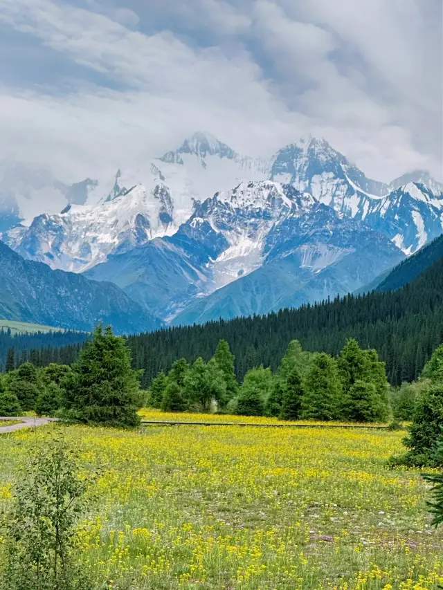
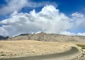
Mount Mousstag is the third highest peak in the Western Kunlun Mountains, at an altitude of 7,546 meters, and the China-Pakistan Highway (314 National Road) detours from the foot of Mousstag Mountain, and you can see the majesty of the snow peak from multiple angles.
MoreSaved by 2
Recommendations Near 慕士塔格風景區
慕士塔格風景區 Reviews: Insider Insights and Visitor Experiences
Some reviews may have been translated by Google TranslateWrite a Review
/5
Outstanding ReviewsAll (5)
Latest
With Photos (4)
Positive Reviews (4)
慕士塔格風景區 Photos: Trip Moments
 I waited a year just for the Xinjiang of May to July, here's an ultra-detailed guide!Life is a wilderness, not a track, hearing a thousand times is not as good as seeing once. Here's a route reference D1: From various places, arrive in Urumqi D2: Urumqi—Sayram Lake—Guozigou Bridge—Ili D3: Ili—Xia'ta—Tekes Hexagonal Town D4: Tekes—Qiongkushitai—Gongliu D5: Gongliu—Qiaxi—Nalati—Northern Section of Duku Highway—Kuqa D6: Kuqa—Kashgar—Kashgar Old City D7: Kashgar—Bai Sha Lake—Muztagh D8: Kashgar—Turpan D9: Turpan—Kumtag Desert—Urumqi Precautions: Remember to rent a car in advance on Ctrip or other reliable platforms before departure, it is recommended to place an order on the platform for security. (Insurance is a must because the distances between each scenic spot in Xinjiang are far, and the driving distance is long, in case of emergency) Xinjiang has a large temperature difference between day and night, prepare 1-2 pieces of thick clothing.! For the long self-driving journey, remember to go to the supermarket to purchase some food for when you get hungry on the road and to replenish energy. Remember to bring your ID card and student ID, if you go to southern Xinjiang or some scenic spots in Kanas, you need to apply for a border pass, which can be done at a nearby police station. Travel tips and outfit suggestions: 1. Remember to wear brightly colored clothes on the grasslands for better photos (such as yellow, pink, purple, etc.). 2. You must visit the pine trees at Sayram Lake, although it's tiring and you may want to give up many times, as long as you persist to the top you will find it's all worth it as you can overlook the entire panorama of Sayram Lake and Guozigou Bridge. 3. Bring some sunglasses and hats for sun protection and also as a fashionable item for better photos (girls can buy a triangular scarf to wear on their head for amazing photos). ps: 'Northern Xinjiang for scenery, Southern Xinjiang for culture', the moment you arrive in Xinjiang, your story begins. Every moment is like a movie playing, the beauty of Xinjiang, no words in this world are enough to describe it.Grace.Roberts.2812
 Xinjiang Southern Region Tourism | 8-Day Pure Play Travel GuideThe 8-day pure play travel guide. The combination of culture and natural scenery in Southern Xinjiang can be described as perfect. Visiting Kashgar allows you to experience the local customs of Xinjiang and see different beautiful landscapes, with the core being the Pamir Plateau. The main features are not flora, but the vast and magnificent snow mountains, lakes, rivers, and landforms... Suggested Itinerary: D1: Departure place - Urumqi D2: Urumqi - en route Wind Power Station - passing by Xinjiang Salt Lake Scenic Area - Korla D3: Korla - Loulan Village - Resitan Street - Kuqa D4: Kuqa - Flaming Spring - Xinjiang Tianshan Tumor Scenic Area·Grand Canyon - Aksu D5: Aksu - Kashgar Old Town - Kashgar D6: Kashgar - White Sand Lake - Muztagh Glacier Park - Golden Beach - Stone City - Taxkorgan D7: Taxkorgan - Panlong Ancient Path - Bandier Lake - Muztagh Peak - Karakul Lake Scenic Area - Kashgar D8: Kashgar - Warm Home Travel Tips: 🔸There is a big temperature difference between morning and evening, so bring seasonal clothes as well as some thick clothes 🔸When going to the Pamir Plateau, be prepared for wind protection and warmth, especially since the Panlong Ancient Path can be quite windy and sandy 🔸Panlong Ancient Path might cause motion sickness, so it's advisable to prepare some motion sickness medicine 🔸The altitude of the Pamir Plateau is high, be aware of altitude sickness and avoid strenuous exercise3ll@ Sc0tt1
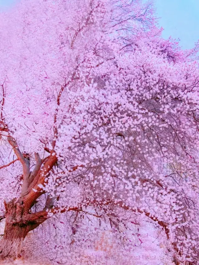 The romance of Southern Xinjiang begins with the apricot blossoms of the Pamir PlateauIt must be the earliest spring in China, a place recommended by 'National Geographic'! This is the Apricot Blossom Village on the Pamir Plateau of Southern Xinjiang. Come spring, century-old apricot trees cover the sky and the sun, mountains and rivers accompany each other, competing to bloom along the perilous Tashkurgan Trail, surrounding the Tajik villages, at the end of March each year, this narrow valley turns into a pink dreamland. The Tajik villages are hidden among them, where earthy yellow and pink interweave, echoing the beauty of the Peach Blossom Spring described by Tao Yuanming. Flower viewing season: Around March 20th to April 10th every year, lasting about half a month Flower viewing route: Kukexiluke Township - Tashkurgan Tajik Autonomous Township - Datong Township Kukexiluke Township: Here, the apricot blossoms bloom between snow-capped mountains and canyons, with a relatively later blooming period than other villages. The primitive earth houses and fields are all blooming with apricot blossoms, definitely a secret garden of apricot flowers Tashkurgan Township: Famous for the Apricot Blossom Avenue, Happiness No.5 Bridge is located here, where old apricot trees bloom densely and grandly, utterly romantic, sure to feast your eyes. Datong Township: Known as 'Peach Blossom Spring - Apricot Blossom Village', every household's yard is filled with century-old apricot trees. Of course, besides apricot blossoms, along the way, we can also see many unique landscapes of the Pamir Plateau, such as White Sand Lake, Red Mountain Valley, Muztagh Ata, Panlong Ancient Trail, Bandier Blue Lake, etc., I have shared the itinerary and accommodation points as follows: 4-day itinerary recommendation: D1: Kashgar - Red Mountain Valley - White Sand Lake - Mujie Volcano Crater - Karakul Lake - Taxkorgan (stay in Taxkorgan) D2: Taxkorgan - Start of the Wakhan Corridor - Panlong Ancient Trail - Bandier Blue Lake - Kukexiluke - (stay in Apricot Blossom Village) D3: Kukexiluke Township - Tashkurgan Tajik Autonomous Township - Datong Township - Taxkorgan (stay in Taxkorgan) D4: Taxkorgan - Tashkurgan Wetland - Muztagh Ata - Karakul Lake - Kashgar (stay in Kashgar) The above itinerary can be adjusted on a small scale. Travel equipment list: Be sure to apply for a border pass first, there are places near the Kashgar Old City. Travel equipment: windbreaker, coat, down jacket, casual shoes, sun protection equipment: sunglasses, sun protection clothing, sun hat Electronic devices: mobile phone, power bank, selfie stick, tripod, camera Medicine: motion sickness medicine, high altitude sickness medicine, cold medicine, essential medicine for special groups Documents: ID card, driver's licenseNomadicEssence
 I'm already looking forward to the epic summer in Xinjiang~Every year at this time, I start to eagerly anticipate the summer in Xinjiang The summer in Xinjiang is really too beautiful!! The summer in Xinjiang is really too beautiful!! . The ultimate spectrum of colors can all be found in Xinjiang The blue of Sayram Lake, the green of Ili, the purple of Huocheng The red of Aoyi Takte, the yellow of the ancient city of Kashgar, the white of Baisha Lake . Xinjiang is particularly large, divided into southern and northern Xinjiang by the Tianshan Mountains ⛰️Southern Xinjiang is the ultimate in culture and the magnificent Pamirs In the ancient city of Kashgar, searching for the traces of 'One Thousand and One Nights' Gazing at the glaciers under the Muztagh Ata The white sands of the Pamir Plateau and the ancient Panlong Path overturn perceptions of Xinjiang 🍃Northern Xinjiang is fan-level wild grasslands Whether it's in Nalati, Qiongkushitai, Qiaxi, or Kanas These are all the grassland highlights of Ili . 🚌Travel route suggestions for Xinjiang ✅Northern Xinjiang·Xinjiang: Urumqi▶️Sayram Lake▶️Guozigou▶️Huocheng▶️Xia'ta▶️Tekes Bagua City▶️Qiongkushitai▶️Nalati▶️Duku Highway▶️Urumqi ✅Southern Xinjiang·Xinjiang: Kashgar▶️Aoyi Takte Red Canyon▶️Baisha Lake▶️Kalakule Lake▶️Taxkorgan▶️Taheman Wetland▶️Panlong Ancient Path▶️Tash Ancient Path (Xia Ban Di Reservoir)▶️Yarkand▶️Kashgar . 🚗Travel transportation suggestions for Xinjiang Xinjiang is really too big!! There are airports in various places in Xinjiang that offer direct flights The best way to enjoy Xinjiang is to rent a car for a road trip, if you can't drive, consider finding a reliable car rental service I played in both southern and northern Xinjiang for 10+ days each, driving a rented car throughout Picked up the car in Urumqi and returned, touring northern Xinjiang Picked up the car in Kashgar and returned, touring southern Xinjiang . ☀️Must-knows for traveling in Xinjiang 1️⃣The climate in Xinjiang is very dry, especially in southern Xinjiang. So be sure to keep moisturized 2️⃣The sunlight in Xinjiang is very strong in ultraviolet rays, so always apply sunscreen when going out, and wear sunglasses and a hat 3️⃣Whether in southern or northern Xinjiang, the distance between each destination is very long, so plan your travel route and timing in advance 4️⃣July and August are the peak tourist seasons in Xinjiang every year, it is recommended to book hotels in advance, especially in popular tourist spots like Qiongkushitaielaranightshade93
 Every person who travels to Xinjiang will eventually return to southern Xinjiang1. Must-visit attractions in southern Xinjiang: 1️⃣ Kashgar: The largest Aitigaer Mosque in Xinjiang, the exotic Gaotai residential houses, the unique Karakuri Lake, and the Mustag Peak it reflects, as well as the highest-altitude port - Khunjerab Pass. Its unique Western Region cultural atmosphere, desolate and atmospheric plateau scenery, tall and pure snow mountain scenery, all touch every inch of your nerves. 2️⃣ Aksu: Aksu has played a huge role since ancient times. At its most glorious, the Aksu region was an important post on the "Ancient Silk Road" connecting Central Asia, West Asia and the Central Plains. 3️⃣ Hotan: Hotan is famous for its jade, but as an important town on the southern line of the ancient Silk Road, it has left many ruins such as the Niya ruins, the Aksu ancient city, the Mailik Awati ancient city, and the Karadun ancient city; the ancient woodblock prints, silk carpet fragments, gold Buddha statues, mummies, ancient coins, etc. unearthed here all shine with the brilliance of ancient civilization. 4️⃣ Bayingolin: Most of Bayingolin Mongolian Autonomous Prefecture is located at the southern foot of the Tianshan Mountains and the north and northeast edge of the Tarim Basin, with a small part located at the southeast edge of the Tarim Basin and between the Kunlun Mountains and the Altun Mountains. Here, there are not only rich alpine grasslands, but also beautiful Bosten Lake, and the most mysterious and desolate Taklamakan in China.Max Kirlin I12
 South Xinjiang Travel Guide | A trip worth taking, don't miss these beautiful itinerariesSouth Xinjiang, as the southern part of the Xinjiang Uyghur Autonomous Region of China, is famous for its unique natural scenery and rich ethnic customs. 🌟Main attractions introduction: Kashgar Old City: An ancient city full of Islamic style and Uyghur ethnic customs, with attractions like the Ga'er Old Town and Id Kah Mosque. Taxkorgan (Tashkurgan): Located on the Pamir Plateau, it features ancient city ruins called Stone City, as well as natural landscapes like White Sand Lake and White Sand Mountain. Muztagh Ata and Karakul Lake: Known as the 'Father of Glaciers', Muztagh Ata, and the profound Karakul Lake. Panlong Ancient Path: Located in Wacha Township of Taxkorgan, a spectacular ancient path in the Kunlun Mountains. Tashkurgan Ancient Path: An ancient path from Taxkorgan to Shache County, with beautiful scenery along the way. Shache County: The ancient kingdom of Shache, the terminal of the southern Silk Road, famous for silk and music. Taklamakan Desert: The world's second-largest desert, the golden season for crossing the desert is from late October to mid-November. 🗓Best time to travel: - The natural scenery of South Xinjiang is most beautiful in autumn, especially in mid-October when the poplar trees turn yellow. It is recommended to travel at the end of October to avoid the National Day and Poplar Festival. 🗓Specific itinerary: Day 1: Fly to Kashgar, stay in the city, and visit Ga'er Old Street at night. Day 2: Head to Karakul Lake, visit White Sand Lake and White Sand Mountain, and stay overnight in a Kyrgyz guesthouse. Day 3: Go to Taxkorgan, visit Stone City, and stay overnight in Taxkorgan. Day 4: Leave Taxkorgan, pass through Ararat Grassland, take the Panlong Ancient Path, and stay overnight in Tashkurgan Tajik Township. Day 5: Cross the Tashkurgan Ancient Path to reach Shache County, and stay overnight there. Day 6: Explore the Taklamakan Desert and return to stay in Shache County. Day 7: Head to Kashgar city to continue exploring the ancient city of Kashgar. Day 8: Leave Kashgar and return. 📝Tips: Xinjiang is vast, and car rides may be long, so those who get carsick should prepare motion sickness medicine. Security checks in Xinjiang are strict; carry your ID card with you. There is a large temperature difference between day and night in Xinjiang; bring enough warm clothing and pay attention to sun protection. It is not recommended for visitors from other places to drive themselves due to strict speed limits and enforcement; it is better to take a local's car. Network signals are good in most areas, but may be slightly poor at high altitudes or uninhabited areas. 🏨Accommodation strategy - You can choose to stay in an RV throughout the trip, which is economical and convenient, and you won't miss the essential attractions. Other suggestions: - If you want to deeply explore South Xinjiang, you may need half a month to experience the local bazaars and cultural customs.KASEN CURTIS1
 Southern Xinjiang Self-Driving Grand Loop Travel Guide!👍Most recommended: Southern Xinjiang Self-Driving Loop Travel Guide! 🌟Highlights: Route highlights: Cover all Southern Xinjiang attractions in one go: ✅ Explore the "Roof of the World" - Pamir Plateau, ✅ Mount Muztagh Ata--known as the Father of Icebergs ✅ Taxkorgan--the westernmost and most awesome county in China ✅ Karakul Lake--a plateau lake at the foot of the "Father of Icebergs" ✅ Taklamakan Desert--China's largest desert, the world's second-largest shifting sand desert ✅ Check in at the popular road--Panglong Ancient Path--over 600 S-shaped bends that will make you "question life" ✅ Xiangfei Tomb--the tomb of Qianlong Emperor's beloved consort "Xiangfei" ✅ Red Flag Lapu Port--China-Pakistan border marker ✅ Kucha's Last Prince's Mansion--Kucha Prince's Mansion 🗓Itinerary: D1, Yinchuan City → Ejina Banner (Travel distance 768km) D2, Ejina Banner → Jingxin Expressway → Hami City (Travel distance 692km) D3, Hami City → Jiaohe Ancient City-Turpan (Travel distance 400km) D4, Turpan → via Bosten Lake-Kucha (Travel distance 640km) D5, Kucha → Kucha Prince's Mansion-Mysterious Grand Canyon of the Tianshan Mountains-Aksu (Travel distance 260km) D6, Aksu → Xiangfei Garden-Kashgar (Travel distance 460km) D7, Kashgar → Kashgar Old City-Century-old Teahouse → Kashgar (Travel distance 0km) D8, Kashgar → White Sand Lake-Muztagh Ata Glacier → Taxkorgan (Travel distance 290km) D9, Taxkorgan → Wakhan Corridor-Panglong Ancient Path → Taxkorgan (Travel distance 280km) D10, Taxkorgan → Karakul Lake → Kashgar (Travel distance 290km) D11, Kashgar → Yarkand → Hotan (Travel distance 480km) D12, Hotan → Desert Highway → Qiemo County (Travel distance 570km) D13, Qiemo County → Loulan Museum → Mangya City (Travel distance 642km) D14, Mangya City → Emerald Lake-Oil Town → Dunhuang (Travel distance 548km) D15, Dunhuang City → Sculpture of the Son of the Earth → Zhangye City (Travel distance 590km) D16, Zhangye City → Wuwei-Crossing Tengger Desert Highway-Yinchuan City (Travel distance 680km) 🧳Pre-trip Preparation: 1. Weather conditions: local temperature, recommended clothing for spring, summer, and autumn, suitable driving shoes, travel shoes 2. Text materials: carry ID card, driver's license, vehicle registration, road maintenance fees and purchase tax, vehicle use tax, route map, credit card, notebook and pen, apply for border pass in advance 3. Daily necessities: mobile phone, rain gear, lighting equipment, insulated water bottle and tableware, photographic equipment, toiletries 4. Medicines: bandages, adhesive bandages, antiseptic solution, anti-inflammatory drugs, heatstroke prevention, motion sickness medicine, mosquito repellent, etc.; 5. Self-prepared snacks: drinking water, functional beverages, self-heating rice, beef jerky, snacks, etc. 6. Vehicle spare parts: a complete set of on-board tools, spare tires, spark plugs, tow ropes, buckets, etc.Lucy.Roberts^19
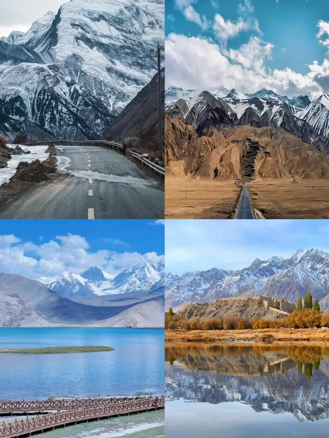
 Heading west, experience the stunning scenery on the Pamir PlateauThe journey from Kashgar to Taxkorgan, the appearance of the White Sand Lake, also kicks off the scenic journey. The official name of White Sand Lake is "Chakrak Lake", locals also call it "Bulunkou Lake", in fact, it is Bulun Reservoir. In 2012, due to the construction of the Gez River Hydropower Station and damming, it eventually turned into a 44 square kilometer water surface, it is also the first of the 11 reservoirs on the Gez River. 🌟Highlights: The surface of White Sand Lake is like a mirror, the sand mountain white sand is like snow, in the distance are the continuous snow mountains, the snow light shines on the White Sand Lake, the White Sand Lake reflects the White Sand Mountain, the three reflect each other, the same color up and down, both illusion and reality. The color of the water surface of White Sand Lake varies under different weather conditions, and the lake and mountain scenery is like an oil painting. ✨Tips: White Sand Lake has two viewing areas, not far apart, the one closer to Kashgar is suitable for distant viewing, the one closer to Taxkorgan is suitable for seeing the white sand, you can take pictures along the way, the scenery is beautiful, but you can't stop the car. 🎫Ticket Information: Cars can only be parked in the two parking lots on the side of the road, the entrance fee is 40 yuan per person, a plank road has been built by the lake, you can go down to the lake, continue to walk towards Taxkorgan there is a free viewing area, with a wide view, and no ticket is required! ⭐️Karakul Lake: Continuing from White Sand Lake towards Taxkorgan is the lake, it is located at the foot of "Father of Glaciers" Mustag Peak, because the lake water is deep and dark, hence the name "Karakul", which means black lake in Kirghiz, at an altitude of about 3600 meters. The lake water is surrounded by mountains, the lakeside is rich in water and grass, often there are Kirghiz herders grazing here. On a clear day, the blue water reflects the silver peaks, the lake and mountain scenery is integrated, the scenery is poetic and picturesque. Here, you can get a close view of Mustag Peak, Gongger Peak, Gongger Jiubie Peak, these three are all over 7000 meters above sea level, they are the iconic snow mountains of the Pamir Plateau. ✅Karakul Lake also requires a ticket, 50 yuan per person. 🚉Travel Strategy: The two lakes are the main attractions from Kashgar to Taxkorgan, you can take a car from Kashgar to Taxkorgan, get off halfway, but it is very inconvenient, it is best to drive by yourself, or join a one-day/two-day tour group in Kashgar.AtlasSage20
 16-Day Panoramic Pure Play Tour of North and South XinjiangNorth and South Xinjiang Grand Loop The gathering is on! You must take a trip to Xinjiang! Visit the Xinjiang Grand Bazaar to stroll through the night market and enjoy delicious food; see the sea-like Sayram Lake; check in at the Nine Turns and Eighteen Bends to witness the spectacle of nine suns reflected in the lake at sunset. If you haven't been to Kashgar, you haven't truly been to Xinjiang. I once thought Xinjiang was all about the Tianshan grasslands and Sayram Lake, the falling leaves at Kanas, the winter snow in Hemu, but it was only after arriving in Kashgar that I realized this is the original look of the Western Regions. 16-Day Panoramic Tour of North and South Xinjiang Itinerary: Day1: From all over the country to Urumqi (pick up at the station) Day2: Urumqi - Tianshan Tianchi - Burqin Day3: Burqin - Kanas·Burqin - Jiadengyu Day4: Jiadengyu - Hemu Scenic Area Day5: Hemu - Colorful Beach - Burqin Day6: Burqin - World Devil City - Kuitun Day7: Kuitun - Sayram Lake - Kuitun Day8: Kuitun - Duku Highway - Nalati Grassland - Nalati Day9: Nalati - Bayanbulak Grassland Day10: Bayan - Tianshan Mysterious Grand Canyon - Kuqa Day11: Kuqa - Xinjiang Tianshan Tomur Scenic Area·Grand Canyon - Aksu Day12: Aksu - Desert Highway - Hotan Day13: Hotan - Kashgar Day14: Kashgar - White Sand Lake - Stone City Jinchao Beach - Taxkorgan Day15: Taxkorgan - Panlong Ancient Road - Karakul Lake - Kashgar Day16: Kashgar - Airport drop-off 【tips】 1. Xinjiang attractions are scattered and far apart, it is recommended to carpool or charter a car for the first visit. 2. Be sure to wear sports shoes, as there are quite a few places to hike in Xinjiang. 3. The ultraviolet rays in Xinjiang are very strong, be sure to protect yourself from the sun. 4. Many scenic spots in Xinjiang have poor signal, it is advised to carry some cash with you. 5. The temperature difference in Xinjiang is significant, even in summer you need to bring a windbreaker, as the weather in the scenic areas changes faster than a person's expression. For more details, consult the guide Wei Xianzhi.SophiaParrish331
You Might Also Like

慕士塔格冰山
1.8
No reviews yet
瓦罕走廊
4.9
5/54 Reviews
Free

塔吉克民俗村
3.5
5/52 Reviews
班迪爾藍湖
3.8
No reviews yet
Free
Nearby Attractions
Pamirs Plateau | Pamir Tourist Area | The Ancient Stone Town of Kashgar | Alar National Wetland Park | Tashiku'erganzhen | Viewing Platform of Taherman Wetland Park | 下阪地水庫 | 班迪爾藍湖 | 坎爾洋村 | 塔吉克民俗村 | Tashenku'ergan Tajike Zizhixian Museum | Taheman Township | 帕米爾金草灘 | Tashkurgan Museum | 塔合曼濕地 | Tizinapu Village | 帕米爾金草灘-觀景台 | 曲什曼拜火教遺址 | 塔什庫爾幹縣歐羅巴温泉莊園 | 阿拉爾金草灘民俗園 | 彩雲人家(民俗村) | 葱嶺湖旅遊景區 | 塔吉克民俗文化展示園 | Baigawule Village | 塔什庫爾幹縣老年活動中心 | Qietimo De'eri | Tashkurgan Library | Tashkurgan Teenagers Activity Center | Pu Luxin Gun'eri | Puta Wuya'er
Popular Types of Attractions in Tashkurgan
Popular Restaurants in Tashkurgan
Xunyangpinwei Restaurant | 冰山来客塔吉克美食餐厅 | 雪上酒店(塔什库尔干红其拉甫路店)·餐厅 | Chongqingquanjiafuchuan Restaurant | 干314国道农家乐 | 牛魔王牦牛滋补馆 | 中巴友谊咖啡厅 | 老传统椒麻鸡 | 雷记高原牦牛骨汤锅馆 | Xiyuniuwangtongguomaoniu | 库米扬文化民宿·塔吉克妈妈味道美食 | 山花快餐 | 雷记高原牦牛骨汤锅馆 | 塔漂咖啡馆 | 盘龙古道快餐厅 | 游云聚美食府 | 花儿为什么这样红音乐餐厅 | 优品味椒麻鸡 | 火炬快餐厅 | 帕米尔家乡美味餐馆 | 碟滋味串串香火锅(塔什库尔干路店) | 蜀香老菜馆 | 蜀滋味 | 丝路帕米尔餐厅 | 谦详益粥铺 | 迪亚热木快餐 | 罕萨厨房(罕萨厨房(幸福小区对面)) | 高原鱼庄石锅鱼 | 帕米尔高原鱼庄 | 胃动力
Popular Destinations
Niagara Falls Travel | Jinan Travel | Ocean Springs Travel | Rocky Mount Travel | Orange County Travel | Salt Lake City Travel | Doha Travel | Holbrook Travel | Addis Ababa Travel | Hong Kong Travel | Nadi Travel | Daegu Travel | Japan Travel | Jilin Travel | Ipoh Travel | Morgan County Travel | Berks County Travel | Oahu Travel | Beaugency Travel | Betsukai Travel | Ruurlo Travel | Viby Travel | Gromitz Travel | Trancoso Travel | Jasper Travel | Saint-Pierre-d'Albigny Travel | Xunyang Travel | Grayslake Travel
Recommended Attractions at Popular Destinations
Bangkok attraction near me | Manila attraction near me | Tokyo attraction near me | Hong Kong attraction near me | Seoul attraction near me | Taipei attraction near me | Los Angeles attraction near me | New York attraction near me | Shanghai attraction near me | Kuala Lumpur attraction near me | Shenzhen attraction near me | Osaka attraction near me | London attraction near me | Singapore attraction near me | Guangzhou attraction near me | San Francisco attraction near me | Beijing attraction near me | Macau attraction near me | Bali attraction near me | Paris attraction near me | Ho Chi Minh City attraction near me | Jakarta attraction near me | Orlando attraction near me | Phuket attraction near me | Chicago attraction near me | Toronto attraction near me | Cebu attraction near me | Istanbul attraction near me | Seattle attraction near me | Dallas attraction near me
Popular Ranked Lists
Top 10 Bars in Amman | Popular Family-friendly Attractions Near Qianyang | Top 21 Local Restaurants in Zhangjiajie | Top 9 Bars in Datong | Popular Family-friendly Attractions Near Haicheng | Popular Luxury Hotels Near Portsea | Popular Premium Hotels in Entremont | Popular Luxury Hotels Near Sanxenxo | Top 6 Bars in Johannesburg | Popular Luxury Hotels Near Portaria | Popular Family-friendly Attractions Near Yuping | Top 7 Bars in Cancun | Top 6 Bars in Haikou | Top 4 Bars in Huizhou | Popular Premium Hotels Near Balige | Top 5 Bars in Changli | Top 16 Local Restaurants in Weihai | Top 19 Local Restaurants in Changchun | Popular Luxury Hotels Near Noizay | Popular Luxury Hotels Near Conshohocken | Popular Family-friendly Attractions Near Yengisar County | Top 7 Bars in Dusseldorf | Popular Luxury Hotels Near Stanley | Popular Family-friendly Attractions Near Pinghe | Popular Family-friendly Attractions Near Hezheng | Popular Luxury Hotels in Kihavah | Popular Family-friendly Attractions Near Tumxuk | Popular Luxury Hotels Near Cambridge | Top 5 Bars in Yiwu | Global Synthesis - Trip.Trends
Popular Trip Moments
Ultimate Babysitter's Guide to Traveling in Southern Xinjiang | Pamir: Plateau, Snow Mountains, Wetlands, Wilderness, and Desert. | A Place Worth Visiting Once in a Lifetime—Baisha Lake and Panlong Ancient Road*. | The Romance of Southern Xinjiang Begins with the Fluttering Apricot Blossoms on the Pamir Plateau. | Taxian Datong Township Xinghuacun | Xinjiang Southern Xinjiang Panlong Ancient Road Loop Guide | Travel to Tashkurgan County | Southern Xinjiang Self-Driving Grand Loop Travel Guide! | Xinjiang Southern Region Tourism | 8-Day Pure Play Travel Guide | The Pamir Plateau, so beautiful it brings tears to your eyes, is worth the journey even with the risk of altitude sickness | 8-Day Tour of Southern Xinjiang | The bluest lake on the Pamir Plateau - Band-e Amir Blue Lake | An autonomous region in the northwest of China | 16-Day Panoramic Pure Play Tour of North and South Xinjiang | Beautiful Memories (4) - The Ruins of the Stone City in Xinjiang | Talk about the strength you have after returning from Xinjiang | I'm already looking forward to the epic summer in Xinjiang~ | I waited a year just for the Xinjiang of May to July, here's an ultra-detailed guide! | South Xinjiang Travel Guide | A trip worth taking, don't miss these beautiful itineraries | One must visit the Pamir Plateau at least once in a lifetime, even if it means enduring altitude sickness | Xinjiang | A hotel at the foot of the Tashkurgan snow mountain, a springtime highland journey | The Best Time to View Apricot Blossoms in Xinjiang~Guide | Explore the Pamir Plateau→Save the message | Exploring the Pamir Plateau → Travel Planning | Explore the Pamir Plateau→Please like and save | Discover the Pamir Plateau→A must-collect for travel enthusiasts | Discover the Pamir Plateau → Travel Knowledge | Explore the Pamir Plateau → If you like, please leave a message | Exploring the Pamir Plateau → Travel Guide Sharing | Explore the Pamir Plateau → Worth a like
Popular Travel Types
More Things To Do in Tashkurgan
One-day attraction to Muztagh Peak and Karakul Lake in Kashgar, Xinjiang, China [One-day tour to Karakul Lake - small package tour] | 7-Days Autumn Tour to Hunza Valley | Trip to Fairy Meadows and Hunza Valley (7 days) | 6-Day Urumqi to Kashgar Private Tour: Heavenly Lake, Kashgar Old Town, Pamirs Plateau | 8-Day Urumqi,Turpan,Kashgar Private Tour include Heavenly Lake, Flaming Mountain | 4-Day Kashgar Private Tour to Karakul Lake, Id Kah Mosque, Abakh Hoja Tomb | 7-Day Urumqi,Turpan,Kashgar Private Tour include Kumtag Desert, Ancient city of Jiaohe | 12-Day South Xinjiang Private Tour included the Taklimakan Desert, Wensu Grand Canyon | Private Tours for Families, Friends, Corporate, Schools or Colleges. | China eSIM Day Pass/data Package days selected without cards QR code | China Mainland eSIM|China Mobile Unlimited 4G High Speed Data | China·Hong Kong·Macau eSIM|Unlimited 4G High Speed Data | [China Mainland] eSIM | SIM to China | 8GB 8days 4G high speed | Asia・Australia eSIM|AIS SIM2Fly 8 days 6GB High-speed Unlimited 5G/4G Data | Mainland China eSIM |China Mobile 4G high-speed unlimited data eSIM | China, Hong Kong, Macau eSim 1/3/7/15/30 days (sent via email) by Xplori | China, Macau eSIM - Data plan by Gohub (QR Code) | AIS SIM2Fly Global eSIM|15 days 6GB high-speed 4G/5G Unlimited Data | eSender - Mainland China eSIM daily package/traffic package, days optional. No need to get the card QR code | Mainland China + Hong Kong + Macau eSIM Data Plan QR Code | China 4G SIM Card (HK, Macau, Taiwan, China Delivery Only) | China/Hong Kong/Macau eSIM 4G high-speed network QR code | [FLASH SALE] China, Hong Kong, Macau eSIM - Data plan by Gohub (QR Code) | eSIM I series in multiple regions around the world | High-speed Traffic for tourism and business Internet access, unlimited Traffic, optional Days, QR code | China, Hong Kong, Macau 4G SIM Card (HK, Macau, Taiwan, China Delivery Only) | Asia 9 Regions eSIM 4G Data Daily Plan QR Code | eSender- Brunei/Indonesia/Singapore/Japan and many other countries and regions eSIM daily package/data package (QR code) | Global multi-region A series eSIM|High-speed data, travel and business Internet access, optional unlimited data, optional days, QR code | Asia 9 Destinations eSIM 4G Data Plan QR Code | Global (30 Countries) eSIM Data Package (QR Code)
About
Payment Methods
Our Partners
Copyright © 2024 Trip.com Travel Singapore Pte. Ltd. All rights reserved
Site Operator: Trip.com Travel Singapore Pte. Ltd.
Site Operator: Trip.com Travel Singapore Pte. Ltd.
Mount Mousstag is the third highest peak in the Western Kunlun Mountains, at an altitude of 7,546 meters, and the China-Pakistan Highway (314 National Road) detours from the foot of Mousstag Mountain, and you can see the majesty of the snow peak from multiple angles.
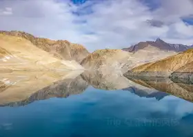
The Moustage Peak is round, a glacier hanging, the ice crystal is transparent, amazing, as long as you look at it, you can no longer move your sight. Moustage Peak, the third peak of the Western Kunlun Mountain vein, is 7,546 meters above sea level, and the top of the mountain is snowy all year round. Uyghur means "father of icebergs".
Tahaman Wetland is located in the Tashkurgan area of Kashgar, Xinjiang, in the east of the Pamir Plateau, at the foot of Mustagh Peak, more than 3,000 meters above sea level, surrounded by mountains, the largest wetland in Tashkurgan.
The scenery is beautiful, and the snow-capped mountains are seen at a close distance, and the photos are very beautiful. The air is also very good.
🏞 The car galloped on G314 and entered the territory of Tashkurgan, and officially entered the Pamir Plateau. 🏔 From then on, Mustag Peak and its adjacent Gonggel Peak, as well as Gonggel Jiube Peak, became a loyal background board. Under the blue sky, it glowed. 🗻 The snow that is perennial is not only a beautiful scenery on the plateau, but also a wetland and meadow, so that the Ta people can live and work in this land for generations. 🧗♂️ Moustag Peak is also the goal that climbers want to conquer. Do you want to try it? #Discover the color of the journey #Views on the road #Views under the drone lens