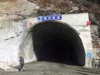
Doxiongla Mountain is the first obstacle for hikers to hike Moto. It is about 4500 meters above sea level. Among them, the Doxiongla Mountain Pass is more than 4200 meters above sea level, which is the highest point of Moto's whole hiking journey. La, in Tibetan, it means Gao, such as Tanggula and Mira. Walk to Melt - Paizhen to Lag, pass through the Pass of Doxiong La Mountain. By the end of 2016, the Doxiongla Tunnel of the Paimo Highway was opened, which solved the problem of the past. Because it's near the snow line, you can see both snow and rippling streams.
;
Duoxiongla Snow Mountain Review
4.7 /520 Reviews


1 / 3


5/5
Duoxiongla Snow Mountain
Posted: Apr 27, 2018


3 person liked this
Like
 5/5OutstandingOriginal Text
I have long known Doxiongla Mountain, because this is a relatively well-known hiking road into Metuo, only a short time each year can climb this mountain, and then pass through the grasshopper area, all the way hard, difficult. Because it is too dangerous, it is now not encouraged to cross, and as Bomi to Motuo, the town to Motuo road is gradually opened, it will become more and more deserted.
Posted: Nov 17, 20210 5/5OutstandingOriginal Text
In the Yarlung Zangbo Grand Canyon Scenic Area, it is easy to see Nanga Bawa Peak, but it is still easy to see Doxiongla Mountain. After all, the altitude is relatively low and you can see it clearly. If you want to go to Metuo, it is also very challenging to walk here.
Posted: Jul 25, 20200 4/5ExcellentOriginal Text
Look at this long Jichangshan Road, I climbed so many times that I was about to collapse, and I tried to cheer myself up. I insisted on insisting on it. I actually went up the mountain slowly. The biggest harvest, blue sky and white clouds, wild roads, chariots, donkeys and donkeys, appeared on the mountain together.
Posted: Aug 2, 20190 5/5OutstandingOriginal Text
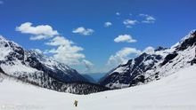
The wind is strong and foggy, there is no sunshine all the year round on the mountain, the temperature is very low, and the summer is also above and below zero. This is the only place to walk through to Moto. There are also cyclists. From time to time, they can see the people carrying their bags and bicycles. Sincerely Perth!
Posted: Feb 17, 20173 5/5OutstandingOriginal Text
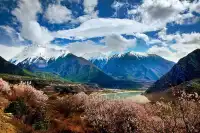
Linzhi seems to be the beautiful south of the Yangtze River in the arms of a giant dragon. By September, the barley inlaid in Linzhi's fields was dyed golden. When the wind swept, the golden ocean surged. At this time, strolling along the lake, as if in the colorful forest, across the shore, the snow-capped mountains stand on the horizon. Blue sky, white snow, colourful forests and lakes shine in front of each other. This colorful landscape like an oil painting must not be missed.
Posted: Aug 2, 20170- 1
- 2
- 3
- 4
Duoxiongla Snow Mountain Frequently Asked Questions
More Questions
Preston_Dominguez: Junction of Milin County and Motuo County, Metog County 860700, China
1 Answer
Popular Destinations
Kissimmee Travel | Sri Lanka Travel | Qingdao Travel | Miami Beach Travel | Windsor Travel | Indianapolis Travel | Somerset Travel | New Orleans Travel | Rayong Travel | Athens Travel | Anastasia Island Travel | Philippines Travel | Yantai Travel | Boston Travel | Tagaytay Travel | South Korea Travel | Charleston Travel | Iloilo City Travel | Bataan Travel | Split Travel | Jiande Travel | Lazi Travel | Citta della Pieve Travel | Sodermanland Travel | Mysore Travel | Parramatta Travel | Lewiston Travel | Rocky Mount Travel | Portland Travel | Cheyenne Travel
Recommended Attractions at Popular Destinations
Bangkok attraction near me | Tokyo attraction near me | Manila attraction near me | Hong Kong attraction near me | Seoul attraction near me | Taipei attraction near me | Los Angeles attraction near me | New York attraction near me | Shanghai attraction near me | Shenzhen attraction near me | Kuala Lumpur attraction near me | Osaka attraction near me | Guangzhou attraction near me | Singapore attraction near me | London attraction near me | San Francisco attraction near me | Beijing attraction near me | Macau attraction near me | Bali attraction near me | Ho Chi Minh City attraction near me | Paris attraction near me | Orlando attraction near me | Jakarta attraction near me | Phuket attraction near me | Chicago attraction near me | Toronto attraction near me | Cebu attraction near me | Dallas attraction near me | Istanbul attraction near me | Dubai attraction near me
Popular Attractions
Osaka Castle Park | Carnival Magic Phuket | Sunway Lagoon Theme Park | Victoria Harbour | Hobbiton™ Movie Set Tours | Palais Garnier | Skydeck Chicago | Aquaria Phuket | Miniatur Wunderland | Singapore Zoo | Chimelong Safari Park | Prague Castle | Georgia Aquarium | Salvador Dalí House Museum | Ashikaga Flower Park | San Jose Monastery of Discalced Carmelites | O'Fallon Assembly of God | Central Church of the Nazarene | Mt Carmel AME Zion Church Camp Meeting | Wallfahrtskirche Allerheiligen | Shree Mahalaxmi Mata Mandir | Tablighi Markaz Zakariya Masjid | Church of the Lord Jesus Christ | Gemeindebüro Evangelische Michaelsgemeinde Mainz-Kostheim | Temple of Heaven | Badaling Great Wall | The Metropolitan Museum of Art | Ocean Park Hong Kong | Ferrari World Abu Dhabi | Lujiazui
Popular Travelogues
Bangkok Travelogue | Tokyo Travelogue | Manila Travelogue | Hong Kong Travelogue | Seoul Travelogue | Taipei Travelogue | Los Angeles Travelogue | New York Travelogue | Shanghai Travelogue | Shenzhen Travelogue | Kuala Lumpur Travelogue | Osaka Travelogue | Guangzhou Travelogue | Singapore Travelogue | London Travelogue | San Francisco Travelogue | Beijing Travelogue | Macau Travelogue | Bali Travelogue | Ho Chi Minh City Travelogue | Paris Travelogue | Orlando Travelogue | Jakarta Travelogue | Phuket Travelogue | Chicago Travelogue | Toronto Travelogue | Cebu Travelogue | Dallas Travelogue | Istanbul Travelogue | Dubai Travelogue
Popular Ranked Lists
Popular Nightlife Districts in Lijiang | Top 19 Fine Dining in Milan | Top 12 Fine Dining in Edinburgh | Popular Nightlife Districts in Hong Kong | Top 15 Fine Dining in Chongqing | Popular Premium Hotels Near Sucre | Popular Premium Hotels in Claremont | Popular Family-friendly Attractions Near Huangmei | Popular Luxury Hotels in Can Tho | Popular Family-friendly Attractions Near Shishi | Top 7 Fine Dining in Krabi | Popular Family-friendly Attractions Near Zhongxiang | Popular Luxury Hotels Near Kavos | Top 5 Fine Dining in Shenyang | Popular Nightlife Districts in Seoul | Popular Nightlife Districts in Las Vegas | Top 6 Bars in Changchun | Popular Nightlife Districts in Phuket | Popular Luxury Hotels Near North Lombok Regency | Popular Family-friendly Attractions Near Qian County | Top 4 Nightlife Districts in Tokyo | Top 4 Nightlife Districts in Osaka | Top 5 Nightlife Districts in Bangkok | Popular Nightlife Districts in Hong Kong | Popular Nightlife Districts in Dublin | Popular Nightlife Districts in Las Vegas | Popular Nightlife Districts in Phuket | Popular Nightlife Districts in Taipei | Popular Nightlife Districts in Chengdu | Popular Nightlife Districts in Jinghong
About
Payment Methods
Our Partners
Copyright © 2024 Trip.com Travel Singapore Pte. Ltd. All rights reserved
Site Operator: Trip.com Travel Singapore Pte. Ltd.
Site Operator: Trip.com Travel Singapore Pte. Ltd.