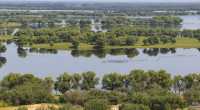
Xianghai was originally known as "Xianghai", and the national nature reserve is located in Tongyu County, Baicheng, Jilin Province, in the middle of the Horqin grassland. It is a national nature reserve, the total area of the national AAAA-level nature reserve and the international AAA-level nature reserve is 10.67 10,000 hectares, which is a typical grassland landscape. The longest is 45 kilometers from the north to the south, the widest is 42 kilometers from the east to the west, and the west is bordered by the right central flag of Inner Mongolia Ke and the north is adjacent to the city of Weinan. The southern part of the protected area has the Huolin River running through the east and west, the Emutai River in the middle into the wetland, and the north leads the water into the reservoir of the Shao'er River. The protected area spans five township farms, twelve villages and thirty-two natural villages in Tongyu County, and 20,000 people are engaged in agriculture, forestry, animal husbandry, deputy and fishing industries in the area.
;
Xianghai Nature Reserve Review
4.6 /5162 Reviews


1 / 5


5/5
Xianghai Nature Reserve
Posted: Nov 25, 2019

5 person liked this
Like
 5/5OutstandingOriginal Text
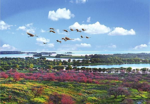
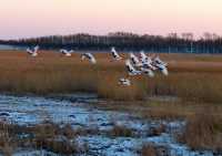
Xianghai Reserve is located in the southwest of Xinglongshan Town, Xianghai Township, Tongyu County, Jilin Province, with an area of about 100,000 hectares. It was established in 1981 and was a national wetland reserve in 1986. There are more than 10 first-class animals and more than 40 second-class animals in the area, mainly for rare birds such as red-crowned cranes and egrets. The main attractions in the area are Crane Island, Museum, Xianghai Temple, Huangyu Forest and so on.
Posted: Jan 31, 20240 5/5OutstandingOriginal Text
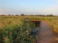
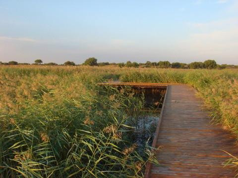
The Xianghai Nature Reserve in the middle of the Horqin Grassland in Tongyu County, Baicheng Province, Jilin Province, can be boarded in the sea pavilion, the wind is very strong, overlooking the sea, one side is the endless sea, the other is the wetland with dead trees, the sunset is really beautiful.
Posted: Dec 16, 20220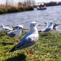 5/5OutstandingOriginal Text
A beautiful scenic spot, a place to go. Driving from Baicheng for more than an hour, the road conditions are very good. When you arrive at Xianghai, you must go to the Lanhai Pavilion, stand on it, and you can see all the scenery of Xianghai Scenic Area.
Posted: Oct 20, 20222 5/5OutstandingOriginal Text
Xianghai was originally known as Xianghai, and the national nature reserve is located in Tongyu County, Baicheng City, Jilin Province, in the middle of Horqin Grassland. It is a national nature reserve.
Posted: Aug 8, 20230- 5/5OutstandingOriginal Text
Can only say: really beautiful. The area of the reserve is also very large. The best thing is that you can see the whole view of the sea from the top of the Lanhai Pavilion. This feeling is definitely a different experience. The scene of various migratory birds flying on the lake is spectacular when they come
Posted: Oct 15, 20222 - 1
- 2
- 3
- 4
- 33
Xianghai Nature Reserve Frequently Asked Questions
More Questions
Jeremy_Dodson: I recommended Xianghai Wetland,Jilin Xianghai Ziran Museum,World of Birds
1 Answer
Messiah_Dillon: Here are some hotels near Xianghai Wetland: XIANGHAIDAJIUDIAN,,,,
1 Answer
Judah_Dillard: You could try YOU XIAN JU YU GUAN,Youxianju Restaurant,,,
1 Answer
Popular Destinations
Connecticut Travel | Harbor Springs Travel | Munich Travel | Austin Travel | Kota Belud Travel | Shantou Travel | Calgary Travel | Nashville Travel | St. Catharines Travel | Langkawi Travel | Seaside Heights Travel | Frankfurt Travel | Shenyang Travel | Lahore Travel | Subic Bay Travel | Novi Travel | Icheon Travel | Abidjan Travel | Hulunbuir Travel | Venice Travel | Kerhonkson Travel | Hiddensee Travel | Le Mont-Dore Travel | Saint-Pierre-d'Oleron Travel | Vadoo Travel | Klamath County Travel | Franklin County Travel | Yelegiri Travel | Meizhou Travel | Xingtang Travel
Recommended Attractions at Popular Destinations
Bangkok attraction near me | Tokyo attraction near me | Manila attraction near me | Hong Kong attraction near me | Seoul attraction near me | Taipei attraction near me | Los Angeles attraction near me | New York attraction near me | Shanghai attraction near me | Shenzhen attraction near me | Kuala Lumpur attraction near me | Osaka attraction near me | Guangzhou attraction near me | Singapore attraction near me | London attraction near me | San Francisco attraction near me | Beijing attraction near me | Macau attraction near me | Bali attraction near me | Ho Chi Minh City attraction near me | Paris attraction near me | Orlando attraction near me | Jakarta attraction near me | Phuket attraction near me | Chicago attraction near me | Toronto attraction near me | Cebu attraction near me | Dallas attraction near me | Istanbul attraction near me | Dubai attraction near me
Popular Attractions
Picasso Museum Barcelona | Singapore Flyer | Güell Palace | Osaka Aquarium Kaiyukan | Zoo Miami | Yokohama Hakkeijima Sea Paradise | Tiger Kingdom - Phuket | JOJOZOO PARK九九峰動物樂園 | Seville Cathedral | LEGOLAND California | New Jersey SEA LIFE Aquarium | Monterey Bay Aquarium | Bali Bird Park | KunLunYu WenHua ChenLieGuan | Recreation Park of the Biysk Home for the Elderly and Disabled | Reflection Children's Musical Theater | Proletarskiy Park OfCulture and Leisure | Verteks Art Studio | GongXian ShangYe BuXingJie | Victory Dendropark | S. Kirov Park of Culture and Leisure | Samokhval Recreation Park | Universal Orlando Resort | Universal Studios Japan | Keukenhof | The Museum of Modern Art | Statue of Liberty | Tokyo Disneyland | Park Güell | Hong Kong Disneyland
Popular Travelogues
Bangkok Travelogue | Tokyo Travelogue | Manila Travelogue | Hong Kong Travelogue | Seoul Travelogue | Taipei Travelogue | Los Angeles Travelogue | New York Travelogue | Shanghai Travelogue | Shenzhen Travelogue | Kuala Lumpur Travelogue | Osaka Travelogue | Guangzhou Travelogue | Singapore Travelogue | London Travelogue | San Francisco Travelogue | Beijing Travelogue | Macau Travelogue | Bali Travelogue | Ho Chi Minh City Travelogue | Paris Travelogue | Orlando Travelogue | Jakarta Travelogue | Phuket Travelogue | Chicago Travelogue | Toronto Travelogue | Cebu Travelogue | Dallas Travelogue | Istanbul Travelogue | Dubai Travelogue
Popular Ranked Lists
Popular Fine Dining in Hong Kong | Popular Luxury Hotels Near Hiyama District | Top 14 Fine Dining in Bali | Popular Premium Hotels in Ranchi | Top 8 Fine Dining in Qingdao | Popular Luxury Hotels Near Kavros | Popular Family-friendly Attractions Near Gaozhou | Top 10 Clubs in Chicago | Popular Family-friendly Attractions Near Yixian | Popular Family-friendly Attractions Near Langzhong | Popular Family-friendly Attractions Near Linze | Popular Premium Hotels in Constanta | Top 9 Clubs in Phnom Penh | Top 5 Nightlife Districts in Bangkok | Popular Premium Hotels in Pamukkale | Popular Premium Hotels in Girvan | Popular Fine Dining in Hangzhou | Popular Fine Dining in Singapore | Popular Family-friendly Attractions Near Pingle | Top 12 Fine Dining in Changsha | Popular Nightlife Districts in Hong Kong | Popular Nightlife Districts in London | Popular Nightlife Districts in Changsha | Popular Nightlife Districts in Kaohsiung | Popular Nightlife Districts in Lijiang | Top 5 Nightlife Districts in Bangkok | Top 4 Nightlife Districts in Tokyo | Top 4 Nightlife Districts in Osaka | Popular Nightlife Districts in Pattaya | Popular Nightlife Districts in Las Vegas
About
Payment Methods
Our Partners
Copyright © 2024 Trip.com Travel Singapore Pte. Ltd. All rights reserved
Site Operator: Trip.com Travel Singapore Pte. Ltd.
Site Operator: Trip.com Travel Singapore Pte. Ltd.