


1 / 9

Mentioned in This Moment
3/56 reviews | Mountain Climbing
Dingri
View
Show More
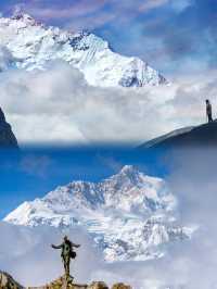
Mount Everest
Wyatt.Campbell.38
Four days from Lhasa to Everest Base Camp
Foodventures
Back from Tibet, and the rambling begins
Traveler sTales
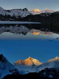
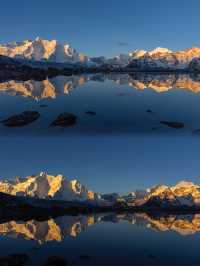
Seven magnificent and majestic snow-capped mountains within the territory of Tibet
Luna_3_Winterthorn*52
Climb to Everest 🏔️ Base Camp
JoMi Silver
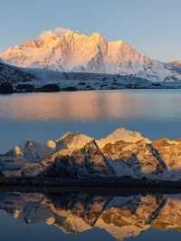
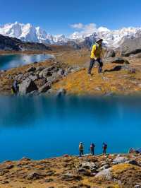
Leisure time at Everest Base Camp
SeraphinaAurelius890^
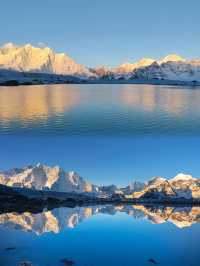
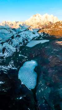
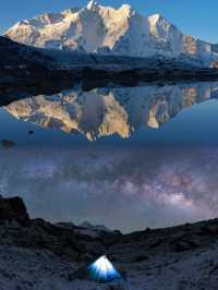
Everest: From distant to present miracle
nysara_5465
Average 3-4k! Winter travel to Tibet is simply winning
NomadicWanderer_777
Popular Trip Moments
Entering the Gama Valley, you surpass 99% of the people on Earth | Mount Everest | Four days from Lhasa to Everest Base Camp | Back from Tibet, and the rambling begins | Seven magnificent and majestic snow-capped mountains within the territory of Tibet | Mount Everest East Slope | An essential item on the 2024 hiking checklist | Climb to Everest 🏔️ Base Camp | Everest Five-Day Tour | The must-choose route for the first trip to Tibet | Mount Everest is beautiful, but I won't come again next time, take my advice! | Leisure time at Everest Base Camp | Everest: From distant to present miracle | Average 3-4k! Winter travel to Tibet is simply winning | Detailed guide for traveling to Tibet during the Spring Festival, any help is a help! | A super comprehensive guide to Everest from September to November is here | 2023-10-13 Sichuan Yunnan Tibet Xinjiang Gansu Qinghai Sichuan | May the sunshine over the Golden Mountain bring good fortune to all who witness it | Conquering Everest Base Camp's Majesty | A viewing point for Mount Everest that doesn't require a ticket | Traveling to Tibet | Tibet needs to be on your bucketlist | 5200m Everest Base Camp | Third Pole of the Earth 🌎 | Epic view - Lookout to Mount Everest, Tibet | Mt. Everest Base Camp: Tibet | Amazing trip to Tibet and Everest Base Camp | Mount Qomolangma, 8848.86
Popular Travel Types
Popular Destinations
Saint Moritz Travel | Houston Travel | Atlanta Travel | Wuhan Travel | Lahore Travel | United States Travel | Tusayan Travel | San Francisco Travel | Balestrand Travel | Hawaii Travel | Okinawa Travel | Singapore Travel | Vancouver Travel | Tehachapi Travel | Makati Travel | Bridgman Travel | Kavala Travel | Shilin Travel | Munich Travel | Jacksonville Travel | Budd Lake Travel | Lorca Travel | Cortona Travel | Petermann Travel | Timis Travel | Mate Yehuda Travel | Kashiwa Travel | Lanling Travel | Figeac Travel | Saint-Chinian Travel
Recommended Attractions at Popular Destinations
Bangkok attraction near me | Tokyo attraction near me | Manila attraction near me | Hong Kong attraction near me | Taipei attraction near me | Seoul attraction near me | Los Angeles attraction near me | New York attraction near me | Shanghai attraction near me | Kuala Lumpur attraction near me | Shenzhen attraction near me | Osaka attraction near me | Singapore attraction near me | London attraction near me | Guangzhou attraction near me | San Francisco attraction near me | Beijing attraction near me | Macau attraction near me | Bali attraction near me | Paris attraction near me | Ho Chi Minh City attraction near me | Orlando attraction near me | Jakarta attraction near me | Phuket attraction near me | Chicago attraction near me | Toronto attraction near me | Istanbul attraction near me | Dallas attraction near me | Cebu attraction near me | Seattle attraction near me
Popular Attractions
LEGOLAND California | Park Güell | Kennedy Space Center | Palau de la Música Catalana | Salvador Dalí House Museum | Disney California Adventure Park | Art In Paradise Pattaya | Universal Studios Hollywood | Vana Nava Water Jungle | Pandrimalai town | Niagara Falls State Park | Colosseum | Singapore Flyer | Chinatown | Magellan's Cross | Lisbon Zoo | Siam Amazing Park | Kleingärtnerverein Eintracht e.V. | Varahi Mata Temple | Long Fook Baptist Church | Farmington Ranches Park | Golf de Toulouse | The Liljestrand House | Shenley Park | Espace culturel Casse Massion | Communauté Saint Jean | Granary Crafts | Georgia Aquarium | Tokyo Tower | Shedd Aquarium
Popular Restaurants in Dingri
珠峰大本营318观景帐篷营地·餐厅 | Chengduzhuangyuan Restaurant | 白坝一品香川菜 | 平措康桑珠峰大本营富氧酒店·餐厅 | 成都蓉兴餐馆 | 故乡缘川菜 | 重庆饭店 | 兰州风味餐厅(沪聂线店) | 定日氧立方大酒店·彪哥土菜馆 | 疯狂烤吧 | 定日和睦之家 | 常来面馆 | 成都餐馆 | 卓湘 | 利元川妹子饭店(定日店) | YANG GUANG KUAI CAN HAN BAO DIAN | 黑土人家东北饺子城 | Chengdudayi'anrenfanguan | 定日县陕西食府 | 川渝印象餐馆 | 巴蜀香食堂 | 成都酒家 | 华南大饭店 | 大邑三哥饭店 | 蜀兴苑饭庄 | 重庆崽儿火锅串串 | 天府餐厅(日喀则公路管理分局) | 川蒲餐厅 | 四通川菜馆 | 定日欢乐藏餐厅
Popular Ranked Lists
Popular Family-friendly Attractions Near Wulateqianqi | Popular Family-friendly Attractions Near Shantou | Popular Family-friendly Attractions Near Suining | Top 8 Bars in Reykjavik | Popular Family-friendly Attractions Near Tiemenguan | Popular Luxury Hotels Near Bad Tolz-Wolfratshausen | Popular Luxury Hotels Near Santiago de Compostela | Top 19 Fine Dining in San Francisco | Popular Family-friendly Attractions Near Mulei | Popular Luxury Hotels Near Mueang Nga | Top 4 Nightlife Districts in Osaka | Popular Luxury Hotels Near Cordillera Province | Top 9 Bars in Boston | Top 20 Local Restaurants in Las Vegas | Top 20 Fine Dining in Munich | Top 15 Fine Dining in Venice | Popular Luxury Hotels Near Rio Grande | Popular Family-friendly Attractions Near Heshuo | Popular Luxury Hotels Near Banma | Popular Luxury Hotels Near Laguna Beach | Top 4 Nightlife Districts in Tokyo | Top 4 Nightlife Districts in Osaka | Popular Nightlife Districts in Pattaya | Popular Nightlife Districts in Dublin | Popular Nightlife Districts in Las Vegas | Popular Nightlife Districts in London | Popular Nightlife Districts in Phuket | Popular Nightlife Districts in Seoul | Popular Nightlife Districts in Taipei | Popular Nightlife Districts in Beijing
About
Payment Methods
Our Partners
Copyright © 2024 Trip.com Travel Singapore Pte. Ltd. All rights reserved
Site Operator: Trip.com Travel Singapore Pte. Ltd.
Site Operator: Trip.com Travel Singapore Pte. Ltd.