OverviewBookNearbyReviewsWin PrizesRecommended
Share to
Xar Moron Grand Canyon
西拉沐淪大峽谷園區3.6
29 Reviews
Open today at 8:00-17:30
Recommended sightseeing time:1-2 hour
Address:
About 20 kilometers south of Jingpeng Town, Keshiketeng Banner, Chifeng CityMap
What travelers say:
The Xila Mulun Grand Canyon, geology is called the Xila Mulun deep fault, which is located on the southern edge of the Daxingan Mountains, and extends near east-west along the Xila Mulun River, which is 340 kilometers long and 50 kilometers wide. It is one of the most important deep faults in the region.
More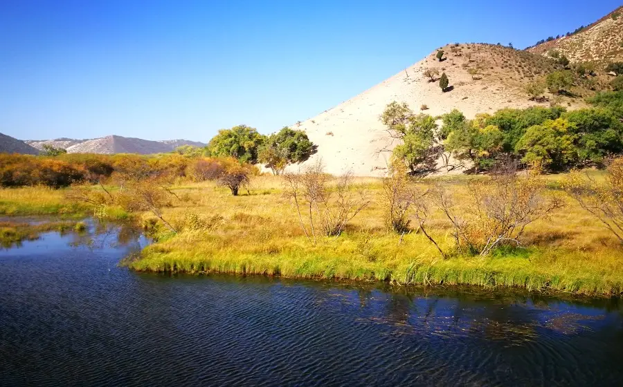
See 1 photo
Xar Moron Grand Canyon Highlights: Must-See Features and Attractions
Some information may have been translated by Google Translate
The Xilamulun Grand Canyon is located on the southern edge of the Greater Khingan Mountains and extends in a near east-west direction along the Xilamulun River. In the scenic area, the mountains are high and the valleys are deep, and the riverbeds jump and leap over the streams, forming Daodao waterfalls. On both sides of the canyon, the bridge is overgrown with shrubs, and the water flow at the source is cut off abruptly. The valley is a long basin. The basin runs from west to east. In some parts of the upper reaches of the Xilamulun River, the two mountains face each other, as steep as a knife, and its height needs to be looked up. When the two banks are close to each other, the cliffs and trees overlap gradually without gaps. When you walk into the cliff corner, the peaks and turns turn around, and there is another cave, known as the "Little Three Gorges". The Xilamulun River converges with the Shali River and the Saling River, and flows straight down, passing through the nine bends and eighteen bays, and entering a cliff canyon two kilometers long. "Longkou". A water park has been built here, where you can go fishing, rafting, and speedboats.
Recommendations Near Xar Moron Grand Canyon
Xar Moron Grand Canyon Reviews: Insider Insights and Visitor Experiences
Some reviews may have been translated by Google TranslateWrite a Review
/5
Excellent ReviewsAll (29)
Latest
With Photos (18)
Positive Reviews (16)
- 1
- 2
- 3
- 4
- 6
Frequently Asked Questions About Xar Moron Grand Canyon
You Might Also Like

Gubei Water Town
7.7
4.7/513994 Reviews
Save $2.76
From $19.34
Simatai Great Wall
5.9
4.7/51119 Reviews
From $5.53
Nearby Attractions
Rehuitang Town | Jingpeng Town | Keqi Qingshan National Geological Park | China Hexigten Global Geopark Museum | Daqingshan Quaternary Period Glacial Relic Park | Hexigten Global Geopark Qingshan Area | Hunshandake Desert | 克什克騰旗龍口漂流 | 草原天牧温泉小鎮 | Jingpeng Square | 熱水塘温泉園區 | Xilamulun Shibawan Drifting | Lierenshu Hot Spring Resort | 克什克騰聯合國教科文組織世界地質公園博物館 | Moulin Wonder | Longkou Lvyou Dujia Center | 鐵馬影視基地 | Keqi Feiyue Taiqiu Club | 東方跆拳道館 | 民族產品彙展中心 | 金木石藝術館 | 應昌街道賽罕社區居民活動中心 | 青山巖臼 | 少兒圖書館 | 克什克騰旗圖書館 | Xiaoke Touhe | Geleihe | Qingning Temple | Wuyi Guan Canal | 三地南溝
Popular Types of Attractions in Keshenketengqi
Nature | Grasslands | Mountains | Forests | Architecture & Landmarks | Squares | Historical Architectures | Featured Neighborhoods | Lifestyle | Resorts | Karaoke | Libraries | Traditional/Cultural Experiences | Villages | Farms | Exhibition Centers | Museums | Fine Art Galleries | Military Sites | Parks | City Parks | Amusement Parks | Botanical Gardens | Historic Sites | Historical Sites | Ancient Pagodas | Religious Sites | Temples | Memorial Temples | Churches and Cathedrals
Popular Restaurants in Keshenketengqi
红山饭店 | 张东子农家院 | 乌兰布统韩家大院餐厅 | 那荣塔拉新派蒙古火锅 | 乌兰布统佰纳观途度假酒店·餐厅 | TU ZI SHAO KAO | 乌兰布统天宏假日酒店餐厅 | 老四烧烤(西边店) | 福源饭庄 | 苗家大院(圣泉路店) | 牧牛手工酸奶坊 | NA RI MAN DA | 乌兰布统龙腾山庄餐厅 | 鱼把头 | Xiaoniu Restaurant | Wanghaiyujia | 陌上花开主题餐厅 | 鑫兴美味家厨 | 顺亿蒙餐私家菜 | 蒙克嘎拉蒙餐 | 胡杨林铁锅灶台鱼 | 品味轩羊汤馆 | XIANG MAN LAO CHENG FAN DIAN | 鱼香居私房菜 | 乌兰布统风行四季酒店·餐厅 | 毛毛虫星期8火锅城 | 0476烧烤 | 牧人居主题餐厅 | CUO YI DU FAN ZHUANG | 克什克腾旗紫蒙山庄
Popular Destinations
Antalya Travel | Pasig Travel | Ely Travel | Abu Dhabi Travel | San Diego Travel | Toronto Travel | Hohhot Travel | Washington D.C. Travel | Moscow Travel | Mt Hood Village Travel | Portree Travel | Vigan Travel | Dubai Travel | Tawau Travel | Kashgar Travel | Dunhuang Travel | Alicante Travel | Winnemucca Travel | Saarbruecken Travel | Canby Travel | McCall Travel | Izabal Travel | Gardena Travel | Kobenhavn K Travel | Beaugency Travel | Conception Bay South Travel | Ruurlo Travel | Viby Travel
Recommended Attractions at Popular Destinations
Bangkok attraction near me | Tokyo attraction near me | Manila attraction near me | Hong Kong attraction near me | Taipei attraction near me | Seoul attraction near me | Los Angeles attraction near me | New York attraction near me | Shanghai attraction near me | Kuala Lumpur attraction near me | Shenzhen attraction near me | Osaka attraction near me | Singapore attraction near me | London attraction near me | Guangzhou attraction near me | San Francisco attraction near me | Beijing attraction near me | Macau attraction near me | Bali attraction near me | Paris attraction near me | Ho Chi Minh City attraction near me | Orlando attraction near me | Jakarta attraction near me | Chicago attraction near me | Phuket attraction near me | Toronto attraction near me | Fukuoka attraction near me | Istanbul attraction near me | Dallas attraction near me | Chiang Mai attraction near me
Popular Ranked Lists
Popular Luxury Hotels Near Beadnell | Popular Luxury Hotels Near Vaughans | Top 16 Local Restaurants in Weihai | Top 9 Clubs in Phnom Penh | Popular Luxury Hotels Near Nikko | Popular Luxury Hotels Near Medhufaru | Top 15 Fine Dining in Chongqing | Top 7 Bars in Luang Prabang | Popular Nightlife Districts in Las Vegas | Popular Family-friendly Attractions Near Longan | Popular Family-friendly Attractions Near Jidong | Top 8 Bars in Kathmandu | Popular Luxury Hotels Near Saga | Top 5 Fine Dining in Foshan | Popular Luxury Hotels in Hawke's Bay | Popular Family-friendly Attractions Near Aketao | Popular Nightlife Districts in Kaohsiung | Popular Luxury Hotels Near Clare | Top 10 Bars in Nanning | Popular Luxury Hotels Near Asprouliani | Top 4 Nightlife Districts in Osaka | Popular Nightlife Districts in Dublin | Popular Nightlife Districts in London | Popular Nightlife Districts in Seoul | Popular Nightlife Districts in Taipei | Popular Nightlife Districts in Kaohsiung | Popular Nightlife Districts in Jinghong | Top 4 Nightlife Districts in Tokyo | Top 5 Nightlife Districts in Bangkok | Popular Nightlife Districts in Pattaya
Popular Trip Moments
The underrated Lake Dalinor, a pearl of the grasslands, where the wind blows the grass low and reveals the sheep and cattle, and the aroma of lamb skewers wafts through the air | Hexigten Banner Museum | Ulan Buh Tourism Area | The golden autumn beauty of Huanggang Liang | Ulan Buh| The autumn here is like a paradise of oil paintings, so beautiful that it moves one to tears!! | Beijing Vicinity | It's not that Harbin is unaffordable, but Bashang offers better value for money | Depart from Shenzhen! Have fun in Qinhuangdao and Inner Mongolia! (Including travel tips) | I lament the fleeting nature of my life and envy the endless beauty of the autumn colors in the Ulan Buh grasslands | Having grasped the vastness of the universe, I still cherish the greenery of plants and trees | Autumn should be wonderful, if you are still around | Embark on a self-driving tour along the Rehe Route in Chifeng, where picturesque scenes await your discovery | Visit the homeland of the grasslands| May you always be well despite the distance | I am very grateful to the platform! From now on, when visiting Ulan Buh, I will stay at this hotel B&B | Suitable for 4+ years old kids! Ulan Bator in the suburbs of Beijing, the real version of Frozen | Ulan Buh! What a divine homestay, living in the happiness of the grasslands | Spend a little money to stay in a boutique accommodation on the Ulan Buh grassland! It's such a great value | City Escape Plan | Ulan Buh Grassland | Thanks to Ctrip for letting me find such a beautiful and affordable boutique homestay on the Ulan Buh grassland | There are so many joys exclusive to winter | Ulan Buh • Two Days and Two Nights • Gather all the autumn limited scenery | The autumn in Ulan Buh is strong | How to choose? Ulan Butong vs Saihanba | 【Weekend Self-driving】Enjoy the beautiful autumn scenery around Beijing | This year's laughter will be repeated next year, and the autumn moon and spring breeze will pass by casually | A good place to go on holiday, Khan Soru International Eco Ranch | October Travel Recommendation!! National Day, go here for sure! | Hulunbuir Grassland | Hiking in Hayao Miyazaki's comics | Self-driving along the Qilu route, come to Hansulux for a luxury camping trip | On the Road - Autumn in Ulan Bator | A snow world that can be reached by driving for 5 hours from Beijing
More Things To Do in Keshenketengqi
Chifeng + Ulanbutong Grassland + Princess Lake Grassland Resort One-Day Tour [Princess Lake Entertainment Package All-inclusive] | China eSIM Day Pass/data Package days selected without cards QR code | China·Hong Kong·Macau eSIM|Unlimited 4G High Speed Data | China Mainland eSIM|China Mobile Unlimited 4G High Speed Data | China, Hong Kong, and Macau eSIM|Total 5GB/10GB/15GB/20GB High-speed 4G LTE Unlimited high-speed data | [China Mainland] eSIM | SIM to China | 8GB 8days 4G high speed | Asia・Australia eSIM|AIS SIM2Fly 8 days 6GB High-speed Unlimited 5G/4G Data | Mainland China eSIM |China Mobile 4G high-speed unlimited data eSIM | Mainland China + Hong Kong + Macau eSIM 4G Data Daily Plan QR Code | Trip.SIM Japan, South Korea, Macau, Taiwan and many places in Asia + Australia and New Zealand 4G travel data roaming phone network card 4 days/7 days | Mainland China + Hong Kong + Macau eSIM Data Plan QR Code | Global multi-region A series eSIM|High-speed data, travel and business Internet access, optional unlimited data, optional days, QR code | China, Hong Kong, Macau 4G SIM Card (HK, Macau, Taiwan, China Delivery Only) | eSender - Mainland China eSIM daily package/traffic package, days optional. No need to get the card QR code | eSIM for China, Hong Kong and Macau. Universal for Mainland China/Hong Kong/Macau. Optional days for travel and business. QR code | AIS SIM2Fly Global eSIM|15 days 6GB high-speed 4G/5G Unlimited Data | Asia 9 Regions eSIM 4G Data Daily Plan QR Code | China, Macau eSIM - Data plan by Gohub (QR Code) | AIS Asia esim data package (QR code) | [Mainland China, Hong Kong and Macau] 4G Internet Card|China Unicom/Hutchison/CTM|Unlimited data SIM card|Number of optional days|Insert the card and use|Self-pickup at Hong Kong Airport | Asia 9 Destinations eSIM 4G Data Plan QR Code | Global multi-region B series eSIM|Universal in 54 countries Travel and business Internet access Optional unlimited data Optional days QR code | eSender- Brunei/Indonesia/Singapore/Japan and many other countries and regions eSIM daily package/data package (QR code) | [Mainland China] 4G Internet Card|China Unicom|Unlimited Data SIM Card|Number of Optional Days|Insert the card and use it|Self-pickup at Hong Kong Airport | [Hong Kong, Mainland China] 4G Internet Card | China Unicom/Hutchison | Unlimited data SIM card | Optional days | Insert the card and use | Self-pickup at Hong Kong Airport | AIS Global esim data package (QR code) | China/Hong Kong/Macau eSIM 4G high-speed network QR code | [FLASH SALE] China, Hong Kong, Macau eSIM - Data plan by Gohub (QR Code) | Global eSim for 140+ countries (sent via email) by Xplori | [China, Hong Kong and Macau] 4G network | Unlimited traffic | Self-pickup at the airport | WiFi rental, high-speed traffic, shared by multiple people, ready to use at startup, 12H standby, 24H customer service
About
Payment Methods
Our Partners
Copyright © 2024 Trip.com Travel Singapore Pte. Ltd. All rights reserved
Site Operator: Trip.com Travel Singapore Pte. Ltd.
Site Operator: Trip.com Travel Singapore Pte. Ltd.
The Xila Mulun Grand Canyon, geology is called the Xila Mulun deep fault, which is located on the southern edge of the Daxingan Mountains, and extends near east-west along the Xila Mulun River, which is 340 kilometers long and 50 kilometers wide. It is one of the most important deep faults in the region.
[Damei Inner Mongolia Keshiketeng Banner] This is the second time we have visited the Keshiketeng Banner in Inner Mongolia Autonomous Region during the Golden Autumn Festival. I didn't go to the Xilamulun Grand Canyon last time, this time I made a special trip. The Grand Canyon of Silamulun did not disappoint us, the colorful colors are simply beautiful!
To be honest, it's a bit pit. The location directly given by the navigation is actually Longkou rafting, with 120 tickets and a bunch of charging items. The Xila Mulun Canyon is actually dozens of kilometers away. The road is in good condition along the river, but unfortunately there are not many places to watch the river view. The last time I went to Huangjiayingzi, looking at the map was the widest part of the river. Parking on the side of the road climbed down the hillside to the river. The scenery was infinite.
Inner Mongolia Keshiketeng Banner is a not-deep canyon, and the Xilamulun River runs through the bottom of the valley. The river is clear, the flow speed is soothing, and the sheep are scattered. The north bank of the river is bare and barren, and the south bank is overgrown with shrubs and green grass. The road extends along the river bank, with few cars and few people and beautiful scenery.
The Xila Mulun Grand Canyon is 20 kilometers away from the Keshiketeng Banner. The road conditions are good. The entrance to the Grand Canyon is asphalt. There is almost no sign in the scenic area. After entering the gate of the scenic spot from the direction of Keqi, you will see the "Black Mountain Hunting Field" sign at about ten kilometers and turn right. Then walk 40 kilometers to the bottom of the Grand Canyon. We walked more than 30 kilometers along the bottom, and the scenery along the bank of the Silas Mulun River was very good!
There is no ticket for the Xila Mulun Grand Canyon. From the inter-provincial passage, I passed the Haoluku Township Government, and turned in at 923 road sign Xiangshui Power Station. It was about 7 kilometers to Xiangshui Power Station. From Xiangshui Power Station, I went all the way to the East Canyon Scenic Area. The autumn is very beautiful. There are few cars to drift and fish. Suitable for wild, pleasant scenery, ask more at the intersection on the road, so as not to go wrong. There is a section of road navigation that can't be done.
On October 4, 2018, the family drove from the Zhenglanqi to the Xila Mulun Canyon to play. From noon to noon, there is a grassland Pearl Meng restaurant in Haolai Hure Township not far from the entrance of the canyon. The dishes are good. After replenishing the energy, drive into the Xila Mulun Canyon area, accompanied by beautiful scenery all the way, and stop at the time, the family has a great time. There is no ticket charge for the canyon. Entering the canyon area, you will see the Xiangshui Reservoir soon. Continue to walk through a narrow cement bridge. After that, the canyon style is in front of you. The rich color of autumn vegetation is draped in the mountains. The road has been accompanied by the Xilamulun River and the beach. The birch forest and poplar forest make people linger...