OverviewNearbyReviewsWin PrizesRecommended
Share to
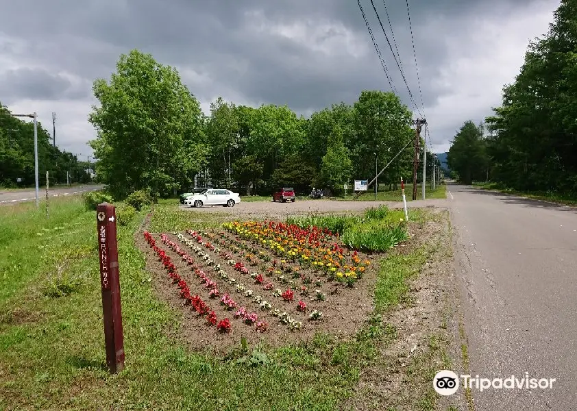
Biruwa Mashu Trail
美留和~摩周展望台登山道1.0
 based on 5 reviews
Address:
Biruwa, Teshikaga-cho, Kawakami-gun 088-3331 HokkaidoMap
Phone+81 15-483-4100
What travelers say:
See all 6 photos
Recommendations Near Biruwa Mashu Trail
Biruwa Mashu Trail Reviews: Insider Insights and Visitor Experiences
Write a Review
 Trip.com
 (5 Reviews)TripAdvisor5 Reviews
You Might Also Like
Shiroi Koibito Park
7.2
4.6/51023 Reviews
From THB 182.06

Noboribetsu Bear Park
6.3
4.5/5231 Reviews
From THB 637.19
Sapporo TV Tower
6.1
4.5/5539 Reviews
From THB 217.51
JR Tower Observatory T38
5.2
4.6/5178 Reviews
From THB 146.70
Nearby Attractions
Lake Kussharo | Lake Mashū | Mount Iō | Lake Mashu Observatory No.1 | Kotan Onsen Hot Spring | Bihoro Pass | Sunayu Onsen | Lake Mashu Observatory No.3 | Roadside Rest Area "Mashū-Onsen" | Kawayuonsen | Uramashu Observatory | Lake Mashu First Observatory | 900 Sougen | Lake Akan | Wakoto Hot Spring | Watanabe Experience Farm | Kawayu Eco Museum Center | Kawayu Onsen Foot Bath | Bihoro Pass Observatory | Taiho Sumo Memorial Museum | Kussharo Kotan Ainu Folk Museum | ビラオの湯 | Kawayu Park Ranch | SOMOKUYA | Teshikaga Country Club | 屈斜路湖サウナ倶楽部 | Suigo Park | Kaminokoike | Tsutsujigahara Nature Trail | Kamenoyu
Popular Types of Attractions in Teshikaga
Parks | City Parks | Zoos | Botanical Gardens | Architecture & Landmarks | Monuments | Observation Decks | landmark | Exhibition Centers | Museums | Planetariums | Art Museums | Lifestyle | Hot Springs | Resorts | Entertainment Centers | Nature | Attractions | Lakes | Nature Reserves | Outdoor Sports | Golf Courses | Hiking | Hiking/Biking | Historic Sites | Historical Sites | Cemeteries | Castles | Popular Spots | Religious Sites
Popular Restaurants in Teshikaga
Teshikaga | Tsujiyashokudo | Wakkanupuri | Orchard Grass | Kumaushi | Rest House in 900 Sogen | Mashuko no Aisu | Mashuko Daiichi Tenbodai Resthouse | Kantorikicchin Chuppu | Mashu no Mori | Kuishinbo | Sobadokoro Fukuzumi, Teshikaga | Blason Dlason | Iouyama Rest House | Toriyaki Manbo | Minshuku Sanko Onsen | Mashu Lake Rest House | Lunch Del Hale | Poppotei | Genpei | Sunayu Rest-house Retarachip | Chinese Restaurant Seiryu | Soba Doraku | JIA BEI DIAN | Mori no Hall | Restaurant & Rider House Ponto | Robata Maruhachi | PANAPANA | Kuro | Shoryuken
Popular Destinations
Zhengzhou Travel | Istanbul Travel | Grundy County Travel | Taipei Travel | Genting Highlands Travel | Montego Bay Travel | Fuzhou Travel | Zhejiang Travel | Koh Samui Travel | Manila Travel | Tucumcari Travel | Taichung Travel | Tinian Travel | Ogallala Travel | Grand Haven Travel | Digby Travel | Sussex County Travel | Baltimore Travel | Ogemaw Township Travel | Itami Travel | La Conca de Barbera Travel | Glendale Travel | Pekalongan Travel | Islas de la Bahia Travel | Ehlanzeni Travel | Belem Travel | Phuket Province Travel | Chiclana de la Frontera Travel
Recommended Attractions at Popular Destinations
Bangkok attraction near me | Manila attraction near me | Tokyo attraction near me | Taipei attraction near me | Hong Kong attraction near me | Seoul attraction near me | Los Angeles attraction near me | Kuala Lumpur attraction near me | Shanghai attraction near me | New York attraction near me | Shenzhen attraction near me | Osaka attraction near me | London attraction near me | Singapore attraction near me | Guangzhou attraction near me | San Francisco attraction near me | Beijing attraction near me | Macau attraction near me | Bali attraction near me | Paris attraction near me | Jakarta attraction near me | Ho Chi Minh City attraction near me | Orlando attraction near me | Phuket attraction near me | Toronto attraction near me | Chicago attraction near me | Cebu attraction near me | Seattle attraction near me | Istanbul attraction near me | Fukuoka attraction near me
Popular Ranked Lists
Popular Luxury Hotels Near McKinley County | Top 21 Local Restaurants in Singapore | Top 16 Local Restaurants in Amsterdam | Popular Family-friendly Attractions Near Yanchuan | Popular Family-friendly Attractions Near Dayao | Popular Family-friendly Attractions Near Jidong | Top 19 Local Restaurants in Da Nang | Popular Luxury Hotels Near Milaidhoo | Popular Luxury Hotels Near Gallatin County | Top 3 Bars in Zhangjiakou | Popular Premium Hotels Near North Banjar Baru | Popular Family-friendly Attractions Near Harqin Left Wing | Popular Family-friendly Attractions Near Ning'er | Top 3 Premium Hotels in Tongli | Top 17 Local Restaurants in Auckland | Top 28 Local Restaurants in Beijing | Popular Luxury Hotels Near Pampatar | Popular Luxury Hotels Near Dawes Point | Popular Family-friendly Attractions Near Mengla | Popular Family-friendly Attractions Near Neixiang | Popular Family-friendly Attractions Near Fenglin County | Popular Luxury Hotels Near Whyalla | Popular Luxury Hotels Near Madrid | Top 22 Local Restaurants in Barcelona | Popular Premium Hotels Near Jazan | Top 17 Local Restaurants in Tokyo | Top 8 Bars in Jiaxing | Popular Family-friendly Attractions Near Jincheng | Top 18 Local Restaurants in Bali | Global Synthesis - Trip.Trends
More Things To Do in Teshikaga
Banff Gondola Ride Admission | 6 Day Canadian Rocky Mountains Explorer Private Tour | Circle West - Canadian Rockies Round Trip Bus Tour From Vancouver | Western Classic - One Way Calgary To Vancouver Rockies Bus Tour | Western Trails - One Way Vancouver To Calgary Rockies Bus Tour | 7 Day Banff Yoho Jasper Waterton NP and Drumheller Tour | 4 Day Banff Yoho Jasper Three National Parks Guided Tour | Fairmont Experience in the Rockies Banff, Japer & Yoho 5-Day Tour | Banff Lake Louise Excursion - 3-Day Calgary To Vancouver Bus Tour | Rockies Western Canada Iconic Sites Tour | Rockies Select 2-Day Tour (Banff & Yoho National Park) | Banff Area & Johnston Canyon 1-Day Tour from Calgary or Banff | Japan eSIM | SoftBank/IIJmio Unlimited 4G High Speed data(Natural day) | Global (66 Countries) eSIM Data Package (QR Code) | Asia・Australia eSIM|AIS SIM2Fly 8 days 6GB High-speed Unlimited 5G/4G Data | [Japan] 4G Docomo | Daily data package | 24H billing | 3-30 days | Uninterrupted network, hotspot sharing support | eSIM QR code | Global Regions eSIM|Unlimited 4G High Speed Data | Trip.SIM Japan, South Korea, Macau, Taiwan and many places in Asia + Australia and New Zealand 4G travel data roaming phone network card 4 days/7 days | Japan eSIM | SoftBank Unlimited 5G high-speed data | Global eSIM J series in multiple regions | High-speed data for tourism and business Internet, unlimited data, optional days, QR code | 【Japan eSIM】Japan eSIM with Unlimited High-speed Data | eSIM Japan by Gohub | Japan eSIM | KDDI, SoftBank Unlimited 4G High Speed Data | Global eSim for 140+ countries (sent via email) by Xplori | AIS Asia eSIM data package (QR code) | AIS SIM2Fly Global eSIM|15 days 6GB high-speed 4G/5G Unlimited Data | Japan eSIM Data Plan QR Code | Japan 4G SIM Card (HK, Macau, Taiwan, China Delivery Only) | Japan eSIM High Speed Network Daily Data (QR Code) | [Japan eSIM] Japan au eSIM with Unlimited 5G/4G Local Data (No throttling)
About
Payment Methods
Our Partners
Copyright © 2024 Trip.com Travel Singapore Pte. Ltd. All rights reserved
Site Operator: Trip.com Travel Singapore Pte. Ltd.
Site Operator: Trip.com Travel Singapore Pte. Ltd.
Film channel 2 time
It is easier to understand from Miruwa. If you walk from the opposite side, a pylon stands right in front of you across the road from the Mashu Daiichi Observatory parking lot, so that is a landmark. The first half is Jari, but it becomes an easy mountain road from the middle.
I went on the opposite route.
As the 6th stage of Kitanemuro Lunchway, hiking from the morning of the summer My trousers are soaked, but the scenery is nice from the middle ❗ The point of note is mites. it's pretty attached to my body. ah, miruwa's water is also delicious.
Kitanemuro lunchway 6 stage
The mountain trail used by Miruwa children to go to Lake Mashu has now been changed to Kitanemuro Lunchway No. 6 stage. If you walk in order from the 1 stage, this is a completely downhill road. 6.6km and the distance is short. Considering the movement after going down, we recommend starting the Mashu Lake First Observatory.
変化もある気持ちのいい道です
美留和駅を出発して雑木林のなかへ。 途中は開けて牧場の合間を歩きます。 クマザサから白樺の林、針葉樹の林と変化があり 最終点は摩周の展望台近くでここから摩周岳の登山道に接続しています。 途中に自販機やトイレはありません。
摩周第一展望台までのフットパス
摩周岳への道ではなくその登山道までの道です。 美留和駅が出発点で最初は平坦です。 途中に引用できるわき水もあります。 最初はけっこう平坦で周囲も牧場や林でフットパスのようですが 2〜3km行くと徐々に上り坂に。 基本的に明るい林か原野なので怖さはありません。