OverviewNearbyReviewsWin PrizesRecommended
Share to
Yaguradake
矢倉岳2.0
 based on 11 reviews
Address:
Minamiashigara, Kanagawa PrefectureMap
What travelers say:

See all 6 photos
Recommendations Near Yaguradake
Yaguradake Reviews: Insider Insights and Visitor Experiences
Write a Review
 Trip.com
 (11 Reviews)TripAdvisor11 Reviews
You Might Also Like
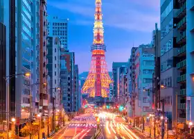
Tokyo Tower
8.2
4.7/53591 Reviews
From PLN 27.92

Tokyo Disneyland
9.5
4.8/59376 Reviews
From PLN 199.79

Yokohama Hakkeijima Sea Paradise
6.0
4.6/5305 Reviews
From PLN 83.46

The National Museum of Emerging Science and Innovation
6.4
4.3/5424 Reviews
From PLN 15.94
Nearby Attractions
Oshino Hakkai | Owakudani | Lake Ashi | Hakone Yumoto Onsen | Hakone Venetian Glass Museum (Glass Forest) | Lake Ashi cruise pier | The Hakone Open-Air Museum | Daiyuzan Saijoji Temple | Lake Yamanaka | Hakone Shrine | Hakone Ropeway | Hakone Kowakien Yunessun | Atami Sea Fireworks | Hakone Tozan Railway | 平和の鳥居 | MOA Museum of Art | Ashigaratōge Pass | Atami Castle | Mishima Sky Walk | Parcabout | Odawara Castle | Hakone Tozan Cable Car | Daiyuzandoryoson | Kawamukai | Atami Onsen Town | Yamanakako Onsen Benifuji no Yu hot spring | Minamiashigarashi Sports Park | Hakone Yuryo | ACAO FOREST | Narukawa Art Museum
Popular Types of Attractions in Minamiashigara
Parks | City Parks | Amusement Parks | Botanical Gardens | Religious Sites | Other Places of Worship | Temples | Churches and Cathedrals | Exhibition Centers | Museums | Art Museums | Art Galleries | Lifestyle | Hot Springs | Entertainment Centers | Libraries | Architecture & Landmarks | Monuments | landmark | Featured Neighborhoods | Historic Sites | Historical Sites | Castles | Cemeteries | Popular Spots | Nature | Lakes | Mountains | Attractions | Outdoor Sports
Popular Restaurants in Minamiashigara
Ashigarakodomanyo Udon | LandLoaf | Tengu Main Store | Hatsuhana Daiyuzan Ekimae | Grill Toshio | Fukuran | Daiko | Daikoku Ichi | Soramame | Komagatatonkatsu | Yakitoriya Numakichi | Cafe de Sol | Angenro | Yoshoku Budosha | Kintokioshokujidokoro | Bean's Village | Dammaya Suisan Daiyuzan | Fureaidokoro Chaya Fujiya | Wadokoro Shinzan | Kappa Sushi | Mellow Legend | Tatsumi No Hiroba | Nagao Chicken | Hokkaitei | Kyotake Shokudo | Tamura Shokudo | Starbucks Coffee - Minami-Ashigara | Chuka Komachi | Restaurant Ashigara | Rikibuto Shoten
Popular Destinations
Puerto Rico Travel | Scunthorpe Travel | Dublin Travel | Miami Travel | Xiamen Travel | Malaysia Travel | Zhangjiajie Travel | Jiuzhaigou Travel | Cairo Travel | Zhuhai Travel | Jinan Travel | Austin Travel | Kyoto Travel | Mohave County Travel | Kauai Travel | Daejeon Travel | Chittagong Travel | Columbus Travel | Izabal Travel | Gardena Travel | Kobenhavn K Travel | Beaugency Travel | Conception Bay South Travel | Ruurlo Travel | Viby Travel | Gromitz Travel | Luganville Travel | Jasper Travel
Recommended Attractions at Popular Destinations
Bangkok attraction near me | Manila attraction near me | Tokyo attraction near me | Hong Kong attraction near me | Seoul attraction near me | Taipei attraction near me | Los Angeles attraction near me | Shanghai attraction near me | New York attraction near me | Kuala Lumpur attraction near me | Shenzhen attraction near me | Osaka attraction near me | Singapore attraction near me | London attraction near me | Guangzhou attraction near me | San Francisco attraction near me | Beijing attraction near me | Macau attraction near me | Bali attraction near me | Paris attraction near me | Ho Chi Minh City attraction near me | Jakarta attraction near me | Orlando attraction near me | Phuket attraction near me | Chicago attraction near me | Toronto attraction near me | Cebu attraction near me | Istanbul attraction near me | Seattle attraction near me | Dallas attraction near me
Popular Ranked Lists
Popular Premium Hotels Near Canmore | Popular Premium Hotels Near Mandalay | Top 4 Fine Dining in Hefei | Top 6 Luxury Hotels in Sardinia | Top 3 Premium Hotels in Quang Binh Province | Popular Family-friendly Attractions Near Boye | Popular Family-friendly Attractions Near Honghe | Popular Family-friendly Attractions Near Qingliu | Popular Family-friendly Attractions Near Jingle | Popular Family-friendly Attractions Near Xixia | Top 19 Fine Dining in Madrid | Popular Premium Hotels in East Kilbride | Popular Luxury Hotels Near Maratea | Popular Premium Hotels in Medina de Tunis | Top 8 Local Restaurants in Fujikawaguchiko | Top 20 Fine Dining in Lisbon | Top 19 Local Restaurants in Changchun | Top 14 Fine Dining in Nagoya | Popular Family-friendly Attractions Near Wucheng | Top 21 Local Restaurants in George Town | Top 3 Premium Hotels in Kaliningrad | Popular Luxury Hotels Near Lower Slaughter | Top 9 Local Restaurants in Malé | Popular Family-friendly Attractions Near Ejin Horo Banner | Top 21 Fine Dining in Taipei | Popular Luxury Hotels Near Debrecen | Top 18 Local Restaurants in Xishuangbanna | Popular Luxury Hotels Near Phaya Yen | Popular Luxury Hotels Near Kappl | Global Synthesis - Trip.Trends
Popular Travel Types
More Things To Do in Minamiashigara
Tokyo Metro METRO + Toei Subway One-day Pass/Two-Day Pass/Three-Day Pass|Tokyo Metro + Toei Subway 24/48/72-hour Ticket | Tokyo Mount Fuji + Kawaguchiko + Hikawa Timepiece Store + Oshino Hakkai + Asana Park Day Tour | Japan Tokyo Mt. Fuji Day Tour | Japan eSIM | SoftBank/IIJmio Unlimited 4G High Speed data(Natural day) | Japan Tokyo Mount Fuji Day Tour [13 people small group optional / selected popular attractions Hakone / Kawaguchiko / optional Hotel pick-up] | Asia・Australia eSIM|AIS SIM2Fly 8 days 6GB High-speed Unlimited 5G/4G Data | Odakyu Line Hakone Freepass 2 / 3days | Japan eSIM | SoftBank Unlimited 5G high-speed data | One-day tour before Kamakura High School in Tokyo, Japan [Tokyo City/Kamakura One-day Tour/Enoshima High School Buddha Slam Dunk Filming Location/Outlets] | [11%OFF]JR Tokyo Wide Pass [Ticket collection at Akihabara]Get a LAOX Duty Free Shop 10% tax-free + 7% discount coupon for a limited time! | Japan Bus ticket Shinjuku to Mount Fuji Station Kawaguchiko Fujikyu Two-way Bus ticket electronic ticket (scan the code to get on the bus + no ticket exchange required) | One-day trip to Owakudani and Lake Ashi Area with Outlet Shopping or Hot Spring Experience | Japan eSIM | SoftBank Unlimited 4G High Speed Data (1 day = 24 hours) | [Japan] 4G Internet Card|CMI|Unlimited Data SIM Card|Number of Optional Days|Insert the card and use it|Self-pickup at Hong Kong Airport | Odakyu Line Hakone & Kamakura Pass(Valid for consecutive 3 days) | Traditional Food and Culture in an Old Shopping District | [Southeast Asia] 4G network | Unlimited traffic | Self-pickup at the airport | WiFi rental, high-speed traffic, shared by multiple people, ready to use at boot, 12H standby, 24H customer service | Private Sightseeing to Mt Fuji and Hakone guide | Private Transfer: Tokyo to Haneda Airport HND in Luxury Van | [Private] Tokyo Personalized Tour (Guide Only) | Private Transfer: Haneda Airport HND to Tokyo in Luxury Van | 【Japan eSIM】Japan eSIM with Unlimited High-speed Data | Hakone Day Tour with Lake Ashi cruise and Ohwakudani | Asakusa: 1400-year history exploration | One-day trip to Tokyo's Mount Fuji Kawaguchiko Panoramic cable car(Kawaguchiko Panoramic cable car, Kawaguchiko Free Matcha Experience, Oshino Hakkai, Fujisan Lawson Store) | Full Day Mt.Fuji & Gotemba Premium to-and-from Tokyo, up to 12 | Arakurayama Sengen Park, Fujiyoshida City, Yamanashi Prefecture, Japan + One-day tour to Oshino Hakkai, Yamanashi Prefecture, Japan [Choose 1 of 2 outlets/hot springs (1 Standard Price) + Hotel pick-up available] | Shop Up A Storm In Ginza | [General in Asia] 4G network | Unlimited traffic | Self-pickup at the airport | WiFi rental, high-speed traffic, shared by multiple people, ready to use at boot, 12H standby, 24H customer service | Japan Tokyo Akihabara Travel Photography [Cyberpunk Cosplay Photography Experience]
About
Payment Methods
Our Partners
Copyright © 2024 Trip.com Travel Singapore Pte. Ltd. All rights reserved
Site Operator: Trip.com Travel Singapore Pte. Ltd.
Site Operator: Trip.com Travel Singapore Pte. Ltd.
Yaguradake Hiking Trail
In the Minamiashigara area, Mt. Yaguradake dominates the local skyline with a symmetrical cone shape that mirrors that of far-off Mt. Fuji. An easy hike to the summit of Mt. Yaguradake starts from t...
The panoramic view from the wide open top is wonderful
Park your car at the Jizodo bus stop and start climbing. It takes about 2 hours to climb a fairly steep slope to reach the top. The summit was wide open, and I could see Mt. Fuji, Hakone, Mt. Kintoki, Odawara City, Sagami Bay, etc. like a panoramic view. On the way back, I went down the Ashigara Old Road on the route through Ashigara Manyo Park. On the way, there was also a signboard for bear witness information. (I brought a bear bell.) The Ashigara Kodo is well maintained and easy to walk.
There is a steep slope, but the view is good
I walked from Yamakita Station with Yan 々. The climb is steep and there is no view to the top of the mountain, but the flat top is perfect for lunch and the scenery is good. It is an old road with a long history, so it is well maintained.
The view of Mt. Jintoki is good.
Looking at the silhouette of Mt. Hakone 々 from the Sagami side, Mt. Kintoki rises to the left hand of Mt. Fuji, and Mt. Yakura rises to the right hand of the flat saddle. The popularity has been handed over to Mt. Kintoki, which is a place to relax on the top of the grass. It seems that it takes less than 2 hours from the trailhead.
Yakura Dake hiking course from ashigara Manyo Park
There were many monuments of Manyoshu in ashigara Manyo Park. One of them (Manyoshu Volume 2 〇 4423) Standing on Misaka in Ashigara, Imo, who is a sleeve-flapped house, is seen in Qing, and is also known as Kyushu. A guard who goes to defend It is a song composed in the thought of my wife who left me at home. From there, go to Yakuradake hiking course. Repeat up and down ...