OverviewBookNearbyReviewsWin Prizes
Share to
Tarim Basin
塔里木盆地3.5
23 Reviews
Open year round, 24/7
Recommended sightseeing time:0.5-1 day
Address:
Xinjiang in northwestern ChinaMap
What travelers say:
The basin is distributed in a circular pattern, with a gravel Gobi connected to the mountain on the edge, a vast desert in the center, an alluvial fan and an alluvial plain between the edge and the desert, and an oasis distribution. The Tarim River is located on the northern edge of the basin and the water flows eastward.
More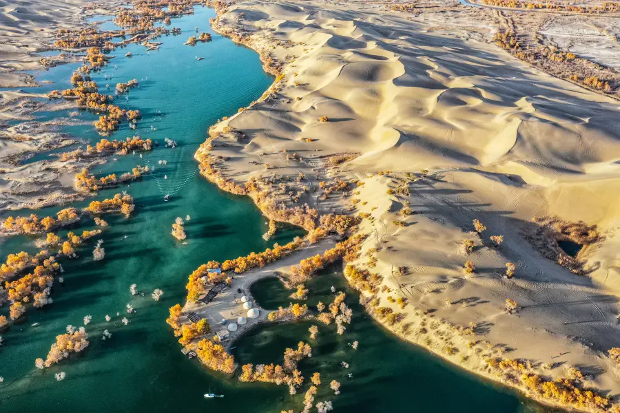
See all 2 photos
Saved by 1
Tarim Basin Highlights: Must-See Features and Attractions
Some information may have been translated by Google Translate
The Tarim Basin is located in the southern part of Xinjiang, China, and is the largest inland basin in China. The basin is located between the Tianshan Mountains, Kunlun Mountains and Altun Mountains. It covers an area of more than 400,000 square kilometers and is 800-1300 meters above sea level. The Tarim Basin is a large closed inter-mountain basin. Geologically, it is a stable block bounded by many deep and large faults. The terrain of the basin is high in the west and low in the east, and dips slightly to the north. The topography of the basin is distributed in a ring shape, the edge is the gravel Gobi connected with the mountains, the center is a vast desert, the edge and the desert are alluvial fans and alluvial plains, and there are oases.
Recommendations Near Tarim Basin
Tarim Basin Reviews: Insider Insights and Visitor Experiences
Some reviews may have been translated by Google TranslateWrite a Review
/5
Excellent ReviewsAll (23)
Latest
With Photos (10)
Positive Reviews (18)
- 1
- 2
- 3
- 4
- 5
Nearby Attractions
Ruoqiang Loulan Museum | 樓蘭文化公園 | Lop Nor | Qiquan Spring | 樓蘭風情園 | Ruoqiang Cultural Palace | 樓蘭烽火台 | 吾塔木鄉文化體育中心 | Ruoqiang Culture Square | Loulan Gymnasium | 星爵桌球俱樂部 | 若羌縣圖書館 | 偉偉網吧 | 若羌縣公共圖書館 | 水立方洗浴中心 | 新疆巴音州若羌縣開心村房車營地(趣滙友自駕遊營地) | 若羌河 | 全季世足 | 若羌縣海龍灣洗浴店 | 斯登桌球俱樂部 | 格納斯桌球俱樂部 | 一桿樂桌球俱樂部 | 若羌縣寰宇KTV | 大眾洗浴(西莎線店)
Popular Types of Attractions in Ruoqiang
Popular Restaurants in Ruoqiang
宫殿美食 | 聚龙自助火锅城 | 回味居拌面 | 阿里巴巴馕坑肉 | 醉仙居酒店 醉仙居酒家 | 回味居饭庄 | 圆月烤肉店 | 百富烤霸(幸福路店) | 国府一品 | 聚源东北烧烤 | 回民饭店 | 农家川菜 | Exiangyuan Hot Pot | 味香园餐厅(长安路店) | 二六工丸子汤(若羌分店) | 回味轩牛肉面 | 德味香东北饭店 | 37度纸包鱼 | 小四川(团结路店) | Zhengshifulazi Chicken | 大自然饭店 | 川福餐厅特色卤猪蹄 | 辣风芹酱香米粉-杰哥早餐小吃店 | 蓝天大众川菜馆 | 百味堂食府 | 老味道特色拌面 | 挚爱约粉(若羌大厦店) | 羊羊羊抓饭店 | 金鹰烤肉王 | 禹龙山庄
Popular Destinations
Port Washington Travel | Miami Travel | Tanay Travel | Duck Key Travel | Zhangjiajie Travel | Philadelphia Travel | Santo Domingo Travel | Jersey City Travel | Guilin Travel | Austin Travel | Kyoto Travel | Lanzhou Travel | Rio de Janeiro Travel | Doha Travel | Qinhuangdao Travel | Gwangju Travel | Zhangzhou Travel | Spain Travel | Greece Travel | Brest District Travel | Americana Travel | Zhada Travel | Versailles Travel | Wangmo Travel | Lesbos Travel | Sodermanland Travel | Skara Travel | Paihia Travel | Chesterfield Travel
Recommended Attractions at Popular Destinations
Bangkok attraction near me | Tokyo attraction near me | Manila attraction near me | Hong Kong attraction near me | Seoul attraction near me | Taipei attraction near me | Los Angeles attraction near me | New York attraction near me | Shanghai attraction near me | Kuala Lumpur attraction near me | Shenzhen attraction near me | Osaka attraction near me | London attraction near me | Singapore attraction near me | Guangzhou attraction near me | San Francisco attraction near me | Beijing attraction near me | Macau attraction near me | Bali attraction near me | Paris attraction near me | Orlando attraction near me | Jakarta attraction near me | Ho Chi Minh City attraction near me | Chicago attraction near me | Phuket attraction near me | Toronto attraction near me | Dallas attraction near me | Istanbul attraction near me | Cebu attraction near me | Seattle attraction near me
Popular Ranked Lists
Popular Family-friendly Attractions Near Qinshui | Popular Luxury Hotels Near Tartu | Top 20 Fine Dining in Abu Dhabi | Popular Family-friendly Attractions Near Baixiang | Popular Fine Dining in Hong Kong | Popular Nightlife Districts in Chengdu | Popular Fine Dining in Paris | Popular Nightlife Districts in Seoul | Popular Premium Hotels Near Varadero | Top 5 Fine Dining in Quanzhou | Popular Luxury Hotels Near Bad Bevensen | Top 15 Fine Dining in Venice | Top 5 Restaurants for Views & Experiences in Manchester | Top 19 Guizhou Cuisine Restaurants in Xingyi | Top 7 Bars in Da Nang | Top 6 Bars in Shijiazhuang | Top 5 Bars in Nanchang | Popular Family-friendly Attractions Near Ningcheng | Top 4 Clubs in Okinawa | Global Synthesis - Trip.Trends | Top 4 Nightlife Districts in Tokyo | Top 4 Nightlife Districts in Osaka | Top 5 Nightlife Districts in Bangkok | Popular Nightlife Districts in Hong Kong | Popular Nightlife Districts in Pattaya | Popular Nightlife Districts in Dublin | Popular Nightlife Districts in Las Vegas | Popular Nightlife Districts in London | Popular Nightlife Districts in Phuket | Popular Nightlife Districts in Seoul
More Things To Do in Ruoqiang
China eSIM Day Pass/data Package days selected without cards QR code | China·Hong Kong·Macau eSIM|Unlimited 4G High Speed Data | China Mainland eSIM|China Mobile Unlimited 4G High Speed Data | China, Hong Kong, and Macau eSIM|Total 5GB/10GB/15GB/20GB High-speed 4G LTE Unlimited high-speed data | Mainland China eSIM |China Mobile 4G high-speed unlimited data eSIM | Asia・Australia eSIM|AIS SIM2Fly 8 days 6GB High-speed Unlimited 5G/4G Data | Mainland China + Hong Kong + Macau eSIM 4G Data Daily Plan QR Code | China, Hong Kong, Macau 4G SIM Card (HK, Macau, Taiwan, China Delivery Only) | Mainland China + Hong Kong + Macau eSIM Data Plan QR Code | Trip.SIM Japan, South Korea, Macau, Taiwan and many places in Asia + Australia and New Zealand 4G travel data roaming phone network card 4 days/7 days | eSender - Mainland China eSIM daily package/traffic package, days optional. No need to get the card QR code | Global multi-region A series eSIM|High-speed data, travel and business Internet access, optional unlimited data, optional days, QR code | eSIM for China, Hong Kong and Macau. Universal for Mainland China/Hong Kong/Macau. Optional days for travel and business. QR code | China/Hong Kong/Macau eSIM 4G high-speed network QR code | Mainland China eSIM high-speed network QR code | AIS Asia esim data package (QR code) | China, Macau eSIM - Data plan by Gohub (QR Code) | [Hong Kong, Mainland China] 4G Internet Card | China Unicom/Hutchison | Unlimited data SIM card | Optional days | Insert the card and use | Self-pickup at Hong Kong Airport | China, Hong Kong, Macau eSim 1/3/7/15/30 days (sent via email) by Xplori | [China, Hong Kong and Macau] 4G network | Unlimited traffic | Self-pickup at the airport | WiFi rental, high-speed traffic, shared by multiple people, ready to use at startup, 12H standby, 24H customer service | Hong Kong eSIM local - Data plan by Gohub (QR Code) | dtac GO INTER eSIM|Asia, Australia, USA 10Days 6GB Unlimited Data | AIS Global esim data package (QR code) | Asia 9 Destinations eSIM 4G Data Plan QR Code | [Mainland China] 4G Internet Card|China Unicom|Unlimited Data SIM Card|Number of Optional Days|Insert the card and use it|Self-pickup at Hong Kong Airport | AIS SIM2Fly Global eSIM|15 days 6GB high-speed 4G/5G Unlimited Data | [FLASH SALE] China, Hong Kong, Macau eSIM - Data plan by Gohub (QR Code) | China 4G SIM Card (HK, Macau, Taiwan, China Delivery Only) | Asia 9 Regions eSIM 4G Data Daily Plan QR Code | Global (30 Countries) eSIM Data Package (QR Code)
About
Payment Methods
Our Partners
Copyright © 2024 Trip.com Travel Singapore Pte. Ltd. All rights reserved
Site Operator: Trip.com Travel Singapore Pte. Ltd.
Site Operator: Trip.com Travel Singapore Pte. Ltd.
The basin is distributed in a circular pattern, with a gravel Gobi connected to the mountain on the edge, a vast desert in the center, an alluvial fan and an alluvial plain between the edge and the desert, and an oasis distribution. The Tarim River is located on the northern edge of the basin and the water flows eastward.
Because the basin is rich in oil and other mineral resources, agriculture is mainly oasis agriculture. The Taklamakan Desert is located in the center of the Tarim Basin, almost the whole year without rain, and is considered to contain rich oil and gas, making a major contribution to the country.
I didn't expect that after living in Tarim for more than ten years, I saw the Tarim Basin. I still feel very kind. Be a camel, and then turn around in the Tarim Desert. It is also a way of leisure travel.
The Tarim Basin is between 800 and 1300 meters above sea level, and the terrain is high and low in the west and east. The eastern Lobbo is the lowest in the basin and the salt center, with an altitude of about 780 meters. The Tarim Basin is bordered by mountains, Gobi and oasis (alluvial plains), and the Taklamakan Desert is in the middle, ranging from 2,000 to 4,000 kilometers in the Pacific, Indian Ocean, Atlantic Ocean and Arctic Ocean. Because of the high mountains in the Tarim Basin, the wet air flow of the ocean is difficult to reach, and the Taklamakan Desert is almost non-rainy all year round. The average annual rainfall is 15-20 millimeters, and the average annual evaporation is as high as 2500-3400 millimeters.
The Tarim Basin is surrounded by Tianshan Mountains, Pamir Plateau, Kunlun Mountains and Arjin Mountains in counterclockwise direction. The eastern side of the mountain is slightly lower, and there is only a valley about 70 kilometers wide that is connected to the Hexi Corridor. The Tarim Basin is elliptical, with the longest east-west about 1,500 kilometers, the widest north-south about 600 kilometers, and the area about 55.59 million square kilometers. It is the largest basin in China.
The Tarim Basin is surrounded by Tianshan Mountains, Pamir Plateau, Kunlun Mountains and Arjin Mountains in counterclockwise direction. The eastern side of the mountain is slightly lower, and there is only a valley about 70 kilometers wide that is connected to the Hexi Corridor. The Tarim Basin is oval, with the longest east and west about 1,500 kilometers, the widest north and south about 600 kilometers, and the total area about 55.59 million square kilometers. The altitude of the Tarim Basin is between 800 and 1300 meters, the terrain is high and low in the west, and the eastern Luobubo is the lowest in the basin and the salt center, with an altitude of about 780 meters.
The Tarim Basin in the southern foot of Tianshan Mountain is the largest inland basin in China. The yellow sand, sand dunes stretching, and the constantly moving Taklamakan Desert witnessed the rise and decline of many ancient Western countries here.