OverviewNearbyReviewsWin PrizesRecommended
Share to
Yushin Valley
ユーシン渓谷2.1
 based on 35 reviews
Open year round, 24/7
Address:
Kurokura, Yamakita-machi, Ashigarakami-gun 258-0202, Kanagawa PrefectureMap
Phone+81 465-75-2717
What travelers say:

See all 4 photos
Recommendations Near Yushin Valley
Yushin Valley Reviews: Insider Insights and Visitor Experiences
Write a Review
 Trip.com
 (35 Reviews)TripAdvisor35 Reviews
You Might Also Like

Sanrio Puroland(Tokyo)
7.7
4.6/51034 Reviews
-€13.83
From €15.00
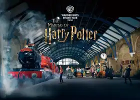
Warner Bros. Studio Tour Tokyo - The Making of Harry Potter
8.8
4.8/51223 Reviews
From €38.25
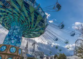
Fuji-Q Highland
6.9
4.7/5424 Reviews
From €29.06
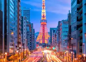
Tokyo Tower
8.2
4.7/53584 Reviews
From €6.49
Nearby Attractions
Oshino Hakkai | Owakudani | Lake Ashi | Arakurayama Sengen Park | Hakone Yumoto Onsen | Hakone Venetian Glass Museum (Glass Forest) | Lake Ashi cruise pier | The Hakone Open-Air Museum | Hakone Shrine | Lake Yamanaka | Hakone Kowakien Yunessun | Hakone Ropeway | Hakone Tozan Railway | Shasui Falls | 平和の鳥居 | Nakagawa Onsen Buna Hot Spring | MOA Museum of Art | Mishima Sky Walk | Yamakita Enno Park | Odawara Castle | Yamakitatetsudo Park | Kanagawa Prefectural Nishitanzawa Visitor Center | Hakone Tozan Cable Car | Kawamukai | Atami Onsen Town | Yamanakako Onsen Benifuji no Yu hot spring | Tanzawa Lake | Snow Resort Yeti | Hakone Yuryo | Ribasakawa Golf Club
Popular Types of Attractions in Yamakita
Parks | City Parks | Amusement Parks | Botanical Gardens | Religious Sites | Other Places of Worship | Temples | Churches and Cathedrals | Exhibition Centers | Museums | Art Museums | Art Galleries | Lifestyle | Hot Springs | Entertainment Centers | Libraries | Architecture & Landmarks | Monuments | landmark | Featured Neighborhoods | Historic Sites | Historical Sites | Castles | Cemeteries | Popular Spots | Nature | Lakes | Mountains | Attractions | Outdoor Sports
Popular Restaurants in Yamakita
Poppo Ekimaeya | Kyogetsu | Tomoshibi Shop Sakura | Michi-no-Eki Kitayama Restaurant | Yamasaki | Furusato | Ayuzawa Parking Area(Tokyo bound lane) Snack Corner | Chabo | Sazareishi | Albero di Cocco | Tonkatsutakara | Mitchan Shokudo | Shimizu Dininig Room | Ikkyu Shokudo | Ochiaikan | Ryumen Hachi | Taiheiraku | Shunka | Yama No Santa | Ramen Gakidaisho Yamakita | Cafe Leafs | Izakaya Tamatei | Vingt-Cinq Ans | Numata | Tachibanaya | Yamagoya Shokudo | Izakaya Yataichi | Healthy Gelato | Shasuien Tarumi Jaya | Shugetsudo
Popular Destinations
Recommended Attractions at Popular Destinations
Bangkok attraction near me | Manila attraction near me | Tokyo attraction near me | Hong Kong attraction near me | Seoul attraction near me | Taipei attraction near me | Los Angeles attraction near me | New York attraction near me | Shanghai attraction near me | Kuala Lumpur attraction near me | Shenzhen attraction near me | Osaka attraction near me | London attraction near me | Singapore attraction near me | Guangzhou attraction near me | San Francisco attraction near me | Beijing attraction near me | Macau attraction near me | Bali attraction near me | Paris attraction near me | Orlando attraction near me | Jakarta attraction near me | Ho Chi Minh City attraction near me | Chicago attraction near me | Phuket attraction near me | Toronto attraction near me | Istanbul attraction near me | Cebu attraction near me | Dallas attraction near me | Seattle attraction near me
Popular Ranked Lists
Popular Family-friendly Attractions Near Jincheng | Popular Luxury Hotels Near Cauayan | Top 3 Luxury Hotels in Basque Country | Popular Luxury Hotels Near Flores | Popular Family-friendly Attractions Near Ninger | Popular Family-friendly Attractions Near Yongxing | Top 5 Nightlife Districts in Bangkok | Popular Family-friendly Attractions Near Kaihua | Popular Nightlife Districts in Kaohsiung | Popular Premium Hotels Near Dhaka | Top 20 Fine Dining in Amsterdam | Popular Family-friendly Attractions Near Lvliang | Popular Nightlife Districts in Hong Kong | Popular Luxury Hotels Near Mimasaka | Popular Luxury Hotels Near West Coast Peninsula | Top 20 Local Restaurants in Las Vegas | Top 15 Fine Dining in Sapporo | Popular Luxury Hotels Near El Girones | Popular Luxury Hotels Near Laem Yai | Popular Premium Hotels in Dhigurah | Popular Family-friendly Attractions Near Ziyuan | Top 5 Fine Dining in Shenyang | Popular Family-friendly Attractions Near Yutai | Popular Fine Dining in Paris | Top 15 Local Restaurants in Doha | Top 16 Local Restaurants in Weihai | Popular Family-friendly Attractions Near Qi County | Top 3 Luxury Hotels in Santa Monica | Popular Luxury Hotels Near Bang Khonthi | Global Synthesis - Trip.Trends
Popular Travel Types
More Things To Do in Yamakita
Tokyo Metro METRO + Toei Subway One-day Pass/Two-Day Pass/Three-Day Pass|Tokyo Metro + Toei Subway 24/48/72-hour Ticket | Tokyo Mount Fuji + Kawaguchiko + Hikawa Timepiece Store + Oshino Hakkai + Asana Park Day Tour | Japan Tokyo Mt. Fuji Day Tour | Japan eSIM | SoftBank/IIJmio Unlimited 4G High Speed data(Natural day) | Japan Tokyo Mount Fuji Day Tour [13 people small group optional / selected popular attractions Hakone / Kawaguchiko / optional Hotel pick-up] | Asia・Australia eSIM|AIS SIM2Fly 8 days 6GB High-speed Unlimited 5G/4G Data | Odakyu Line Hakone Freepass 2 / 3days | Japan eSIM | SoftBank Unlimited 5G high-speed data | Japan eSIM | SoftBank Unlimited 4G High Speed Data (1 day = 24 hours) | One-day trip to Owakudani and Lake Ashi Area with Outlet Shopping or Hot Spring Experience | Japan Bus ticket Shinjuku to Mount Fuji Station Kawaguchiko Fujikyu Two-way Bus ticket electronic ticket (scan the code to get on the bus + no ticket exchange required) | Japan 4G SIM Card (HK, Macau, Taiwan, China Delivery Only) | [11%OFF]JR Tokyo Wide Pass [Ticket collection at Akihabara]Get a LAOX Duty Free Shop 10% tax-free + 7% discount coupon for a limited time! | [Limited time offer] Limousine Bus can depart from Narita Airport/Haneda Airport/city stations | Tokyo Mt. Fuji + Lake Kawaguchi Day Tour | Let's enjoy Scuba diving in Izu Oceanic park Izu Peninsula for certificate Diver | Kawagoe City Kawagoe Ichiban Street + Karuizawa Town Stone Church + Kawagoe Castle Honmaru Palace + Kitain Temple 2-Day Tour [Karuizawa Japan Royal Summer Resort ¥Private Customization] | Japan + Mt. Fuji + Oishi Park Day Tour [Mt. Fuji & Oishi Park & Seasonal Fruit Picking Day Tour] | Mount Fuji + Oshino Hakkai + Lake Kawaguchi + Arakurayama Sengen Park + Kawaguchiko Music Box Forest Art Museum One-day Tour [Chinese Chartered Vehicle Hotel Pick-up ¥ Mount Fuji Private Customization] | Food Tour and Geisha Entertainment in Odawara Castle Town | Haneda Airport Limousine (One-way)|Haneda Airport - Tokyo Down-Town / Bus Terminal Shinjuku | Mt. Fuji + Lake Kawaguchi Day Tour [Including Lake Kawaguchi cable car Fee, Matcha Experience, Free Convenience Store Drinks, Mt. Fuji H Line] | Tokyo + Sensoji Temple + Tokyo Skytree + Ginza + Kabukicho + Shibuya + Ueno Park Day Tour [Tokyo Travel Panoramic Customization] | Japanese Whisky Tasting Experience at Local Bar in Tokyo | Global Regions eSIM|Unlimited 4G High Speed Data | Mt Fuji Day Trip with Private English Speaking Driver | Setagaya Cat Tour! | Secret Food Tours Tokyo w/ Private Tour Option | Private Vacation Photography Session with Local Photographer in Tokyo
About
Payment Methods
Our Partners
Copyright © 2024 Trip.com Travel Singapore Pte. Ltd. All rights reserved
Site Operator: Trip.com Travel Singapore Pte. Ltd.
Site Operator: Trip.com Travel Singapore Pte. Ltd.
Ok
G`day. .... KUROKURA IS CLOSED ❗ after searching for an awesome place to visit, we head off. A few train journeys later we arrived at Shin-Matsuda for the bus connection only to find out that the hik...
Nature in Autumn
We had a glorious day. Weather was amazing and the scenery was wonderful. We saw waterfalls and a real dark tunnel. Without a torch light you will not be able to maneuver through it. We enjoyed the wa...
Be Prepared!
First off, an important warning.There are one or two inviting-looking trailheads off the road course. THESE ARE TOZANDO, NOT HIKING COURSES. i.e. don't go up there without a map, compass or proper GPS...
The mountain trail is rough.
I visited the upstream of Yushin over the pass to move my body while avoiding congestion. Although it was a river with a wide 々, the depths looked blue, and I thought that if there was a water level, it would be beautiful. Since it is a route along the river with a caution display on the mountain climbing map, I chose the weather and visited it, but it seems that the difficulty is increasing due to the collapse of the fragile mountain trail immediately after passing the Ameyama Pass.
Difficulty な Road
I visited by mountain stream fishing, but the road collapsed and traffic was closed. There are traces of falling stones here and there. The transparency of the river is wonderful, but there are not many signs of fish. It seems that the color 々 and the river and the road have changed due to natural disasters such as typhoons.