OverviewBookNearbyReviewsWin PrizesRecommended
Share to
Xiaritala Grasslands
夏日塔拉草原2.5
2 Reviews
 based on 1 review
Recommended sightseeing time:0.5-1 day
Address:
Huangcheng Town, Sunan County 734031, ChinaMap
What travelers say:
Huangcheng is the most east-facing township in Sunan County. It is still very good to go to play in summer. The grassland is green and there are few people. There is a Yuanjian Reservoir near the imperial city and rural area. In July and August, there will be a large area of red grass on the edge of the reservoir (I don't know what grass is), the color is very shocking.
More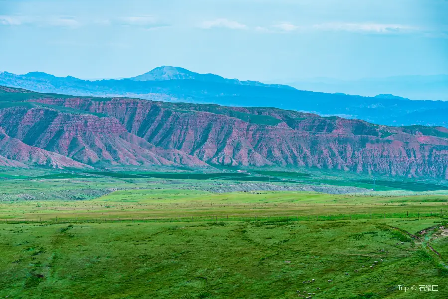
See 1 photo
Xiaritala Grasslands Highlights: Must-See Features and Attractions
Some information may have been translated by Google Translate
Summer Tala Grassland is also known as Imperial City Grassland, which means "golden pasture" in the Yugur language. Here blue sky and white clouds, green grass, tourists can enjoy the beauty of nature and enjoy leisure and slow life here.
Recommendations Near Xiaritala Grasslands
Xiaritala Grasslands Reviews: Insider Insights and Visitor Experiences
Some reviews may have been translated by Google TranslateWrite a Review
 (2 Reviews)Trip.com
 (1 Reviews)TripAdvisor
/5
Outstanding ReviewsAll (2)
Latest
With Photos (1)
Positive Reviews (1)
You Might Also Like
Memory Of Zhangye
5.6
4.9/51356 Reviews
From PLN 85.74
Nearby Attractions
Ba'ersixue Mountain | Kangle Grassland | China Yugu Style Corridor | Palace of King Gesar | 巴爾斯聖山景區 | Qilian Mountain International Ski Field | 神鹿公園 | Hunting Ground of Kanglong Temple, Sunan | Hongwansi | 大經綸 | 祁連山國家公園自然博物館 | 裕固族民俗博物館 | 中華裕固風情走廊景區-觀景台 | Sunan Yuguzu Zizhixian Yingjuyuan Guanli Center | Sunan Theatre | Bai Yazitan | Naleng Geda Lingzi | Cattle Xinduntan | Nationality Park (Southeast Gate) | Heisong Mutan | 裕固族特色村寨 | 排頂墩 | Sunan Publicity Cultural Center Library Children's Reading Room | 肅南縣文化館 | Dalei Bahe | Shi Yaohe | Jiuge Quan'er No. Laochi | Longchanghe | Yinggezui Reservoir | Heishi Touhe
Popular Types of Attractions in Sunan
Nature | Mountains | Lakes | Grasslands | Architecture & Landmarks | Historical Architectures | Squares | Featured Neighborhoods | Exhibition Centers | Museums | Memorial Halls | Military Sites | Religious Sites | Temples | Churches and Cathedrals | Mosques | Historic Sites | Historical Sites | Cemeteries | Lifestyle | Campgrounds | Libraries | Resorts | Parks | City Parks | Botanical Gardens | Traditional/Cultural Experiences | Outdoor Sports | Sports
Popular Restaurants in Sunan
金塔裕固族风情园 | 肃南裕固族自治县茶理一世奶茶饮品书吧 | TENG GE LI DA LA MING ZU JING DIAN | 御品天下美食城 | LI YUAN HE CHA CAN TING | 一味鲜快餐店 | 三杰烤肉玉石根艺收藏大院 | 绿之源天然氧吧休闲农庄 | 赛汗塔拉餐厅 | 川椒麻辣烫 | 马蹄小镇生态农庄 | 临松裕固族风情园 | 大漠烧烤(七彩丹霞店) | 火府茶餐厅 | 印象老味道名小吃 | Xinshishangzizhu Hot Pot | 酸菜牛肉面 | 西至哈志大酒店-中餐厅 | 牧家乐 | 鹿鸣牧家乐 | 新世纪餐馆 | 地方特色小吃城 | 快乐星汉堡(明花路店) | 香园餐馆 | 康乐正宗牛羊肉批发部 | 罗胖子面馆 | 山城小厨 | 高原红民族餐厅 | 大众饭馆(隆畅路店) | 利君牛肉小饭馆
Popular Destinations
Lima Travel | Jakarta Travel | Sydney Travel | Indianapolis Travel | Hong Kong Travel | Langkawi Travel | Venice Travel | Japan Travel | Boston Travel | Houston Travel | Mykonos Travel | Wuhan Travel | Lahore Travel | Riyadh Travel | Changsha Travel | Licata Travel | Spain Travel | Port Dickson Travel | Yogyakarta Travel | Emery County Travel | Moravskoslezsky Region Travel | Borgonovo Val Tidone Travel | Ashton-under-Lyne Travel | Meiringen Travel | Cellole Travel | Valdivia Province Travel | Hakusan Travel | Xingan Travel | Warsaw Travel | Hanzhong Travel
Recommended Attractions at Popular Destinations
Bangkok attraction near me | Tokyo attraction near me | Manila attraction near me | Hong Kong attraction near me | Seoul attraction near me | Taipei attraction near me | Los Angeles attraction near me | New York attraction near me | Shanghai attraction near me | Kuala Lumpur attraction near me | Shenzhen attraction near me | Osaka attraction near me | Singapore attraction near me | London attraction near me | Guangzhou attraction near me | San Francisco attraction near me | Beijing attraction near me | Macau attraction near me | Bali attraction near me | Paris attraction near me | Orlando attraction near me | Jakarta attraction near me | Ho Chi Minh City attraction near me | Chicago attraction near me | Phuket attraction near me | Toronto attraction near me | Cebu attraction near me | Dallas attraction near me | Istanbul attraction near me | Seattle attraction near me
Popular Ranked Lists
Popular Luxury Hotels Near Chamonix-Mont-Blanc | Top 17 Premium Hotels in Yixing | Popular Family-friendly Attractions Near Zhijiang | Popular Nightlife Districts in London | Popular Family-friendly Attractions Near Wuchuan | Top 6 Fine Dining in Taizhou | Top 20 Local Restaurants in Las Vegas | Top 7 Premium Hotels in Changli | Top 4 Nightlife Districts in Osaka | Popular Family-friendly Attractions Near Linxia | Top 18 Local Restaurants in Xishuangbanna | Top 4 Premium Hotels in Bazhong | Top 13 Fine Dining in Florence | Popular Family-friendly Attractions Near Fengcheng | Top 5 Fine Dining in Foshan | Popular Nightlife Districts in Chengdu | Top 4 Premium Hotels in South Sumatra | Top 7 Fine Dining in Dalian | Top 7 Premium Hotels in Zhuzhou | Global Synthesis - Trip.Trends | Popular Nightlife Districts in Dublin | Popular Nightlife Districts in Taipei | Popular Nightlife Districts in Jinghong | Popular Nightlife Districts in Changsha | Top 4 Nightlife Districts in Osaka | Popular Nightlife Districts in Pattaya | Popular Nightlife Districts in Phuket | Popular Nightlife Districts in Beijing | Popular Nightlife Districts in Kaohsiung | Popular Nightlife Districts in Shanghai
Popular Trip Moments
The magnificent cultural and natural scenic spot | Qilian Mountain Snowy Mountains, Mati Temple | The first stop in Zhangye, Gansu - Matisi (Horse Hoof Temple) | Mati Temple in Zhangye | Qilian Mountain National Park | Gansu's 'Little Switzerland', the Qilian Mountains live up to their name | The landforms in the textbook, Binggou Danxia, a fantastical secret realm | Exploring the Hexi Corridor - Zhangye Mati Temple, the unmissable Little Switzerland of the East! | Baiyi Glacier Travelogue | The spectacle of pagoda-shaped grottoes carved into the cliff, you can only climb up with hands and feet | Zhangye Matisi Tourism Experience Strategy Sharing | A Solo Trip to Hexi Corridor - Zhangye Chapter | Zhangye | Low-key and rare, under the snow mountain, the cliff Buddha cave, a glance for a thousand years | In the mountains (1) | Zhangye, under the Qilian Mountains, is the Matisi Temple | I'm sorry, Qilian Mountains, I underestimated your beauty | Cave art, Qilian Mountain scenery, Tibetan style = Zhangye Matisi | 6 things you must know before going to Matisi and Jinta Temple! Zhangye's private strategy! | Winter tour to Zhangye - Matisi Temple | Visiting Gansu in Winter: Worth Experiencing and Finding Hidden Gems | Qilian Mountain Range Scenery | Heaven has lost its palette to the earth, forming the colorful Zhangye Danxia | Qilian Mountain National Forest Park | A Climbing day Mati Temple | Alien Valley 😈👾 | Surreal Alien Valley in Gansu 🇨🇳 | Mati Temple - A Tibetan masterpiece | Stairway to Serenity: Mati Temple | Gansu's Mati Grottoes: Ancient Wonders | Binggou scenic area
Popular Travel Types
More Things To Do in Sunan
Zhangye Colorful Danxia Scenic attraction One-Day Tour [Chartered Vehicle/Multiple Routes Optional/Binggou Danxia/Waixing Valley/Kangle Grassland/Pingshan Lake/Mati Temple] | Zhangye Jinta Temple One-Day Tour [Jinta Temple Special Cave Reservation + Mati Temple In-depth/Door Pickup/Deep into Qilian Mountains/2-6 People Group] | Zhangye Private Day Tour: Zhangye Danxia National Geopark and Horse Hoof Temple Grottoes | Zhangye Private Hiking Tour: Pingshanhu Grand Canyon and Zhangye Danxia Geopark | 2-Day Zhangye Private Tour: Zhangye Danxia Geo Park, Binggou Danxia, Mati Temple Grottoes, Pingshanhu Grand Canyon | 8-Day Silk Road Trip of Dunhuang, Jiayuguan, Zhangye | 8-Day Private Gansu Exquisite Trip from Zhangye | 8-Day Private Silk Road Tour: Xi'ning, Qinghai Lake, Chaka Salt Lake, Zhangye, Jiayuguan, Dunhuang Includes Pirvate Vehicle, Tour Guide and Entrance Fees | Lanzhou Private Day Trip to Tianti Grottoes, Luoshi Pagoda and Leitai in Wuwei | 3-Day Zhangye Private Tour with Danxia Landform Geological Park | Private Hiking Tour: Pingshanhu Grand Canyon and the Horse Hoof Temple Grottoes | 4-Day Tour in Gannan:Zhagana, Milazibafoge, Gahai Lake, Langmu Temple, Labrang Monastery, Zoige Flower Lake | 2-Day Xining Private Tour: Zhuoer Mountain, Daban Mountain, Zhangye Danxia Geopark | 5-Day Private Tour in Gansu: Zhangye Danxia, Jiayuguan Pass, Mingsha Mountain Crescent Spring, Mogao Grottoes | 6-Day Private Tour in Gansu: Zhangye Danxia, Jiayuguan Pass, Mingsha Mountain Crescent Spring, Yumenguan Pass, Mogao Grottoes | 2-Day Zhangye Private Tour: Binggou Danxia, Zhangye Danxia Geo Park, Mati Temple Grottoes | 7 Days Hexi Corridor Adventure Tour to Zhangye, Jiayuguan & Dunhuang | 8-day Gansu Exquisite Hexi Corridor Trip with Accommodation from Zhangye | Zhangye Binggou Danxia attraction One-Day Tour [Optional + Colorful Danxia/Relaxed Business Group/Relaxed and Reliable/Pure Play without Shopping/Natural Wonders] | 8 Day Small Group Tour to West China Qinghai & Gansu | Day tour: Horseshoe Temple Grottoes and Zhangye Danxia Landform | Private Day Tour to Zhangye Rainbow Mount from Lanzhou | 5-Day Private Tour in Gansu: Zhangye Danxia, Jiayuguan Pass, Mingsha Mountain Crescent Spring, Yumenguan Pass, Mogao Grottoes, Yadan Geology Park | Mati Temple attraction+ Zhangye Colorful Danxia Scenic attraction One-Day Tour [Pure Play Selection/Upgrade Business Group/Relaxed and Comfortable/Grotto Temple Complex/Natural Scenic Area] | 7 Days Hexi Corridor Adventure Tour to Zhangye, Jiayuguan & Dunhuang | Zhangye Private Day Tour: Zhangye Danxia National Geopark and Horse Hoof Temple Grottoes | Zhangye Private Hiking Day Tour of Pingshanhu Grand Canyon and the Horse Hoof Temple Grottoes | Day 2 in Zhangye: Binggou Danxia, Zhangye Danxia Geopark, Matisi Grottoes | 3-Day Zhangye Private Tour to Danxia Landform Geological Park, Dafo Temple | 2-Day Zhangye Private Tour: Zhangye Danxia Geo Park, Binggou Danxia, Mati Temple Grottoes
About
Payment Methods
Our Partners
Copyright © 2024 Trip.com Travel Singapore Pte. Ltd. All rights reserved
Site Operator: Trip.com Travel Singapore Pte. Ltd.
Site Operator: Trip.com Travel Singapore Pte. Ltd.
Huangcheng is the most east-facing township in Sunan County. It is still very good to go to play in summer. The grassland is green and there are few people. There is a Yuanjian Reservoir near the imperial city and rural area. In July and August, there will be a large area of red grass on the edge of the reservoir (I don't know what grass is), the color is very shocking.
There is a Huangcheng Reservoir 47 kilometers south of Yongchang County, Gansu. Standing at the reservoir dam, you can overlook the Lenglong Mountain of Qilian Mountain. The snow-capped mountains are reflected on the water, the water and grass along the coast are beautiful, and the cattle and sheep are leisurely and quiet under the blue sky and white clouds. More than 2,000 years ago, Huo Gossick drove the Hunnu from here and found this fat grassland, so he ordered people to raise horses here. I didn't expect this work to last here for 2,000 years. If there is no prompt, passers-by will find the imperial city difficult, mistakenly thinking it is a row of ordinary loess mounds. The composition of Lenglongling, sheep, mounds, grasslands is very harmonious. As for where the mound came from? When did it come? If it is not a purposeful search for the imperial city, I am afraid no one will ask. I didn't meet a passerby here for the first time, until I raised the small plane and was bored to take some sheep material, I was surprised to find its existence. 400m high overlooking the square of the imperial city, the city raft, the moat, the big city gate, the small city gate, and the "work" type high platform where the palace is located. Visually, it is a thousand-person-level earthen plate building the old city. Strangely, the city is empty, still flat grassland, refreshing, no family. Recall the small plane, a group wanted to observe the earth city up close, and when they were approaching, they were stopped by a barbed wire fence, and only sheep could pass. Obviously, the imperial city has not been developed into a tourist attraction. But the local area has recognized its scarcity and preciousness, so it consciously moved to the imperial town two kilometers away. According to the "Yuan Shi Shizu IV", the imperial city was called "tiao diao" before the Yuan Dynasty, and it was under the jurisdiction of Panyu County, Wuwei County (now Yongchang County). It belongs to the Yongchang Wang only to Timuer. Wang Yongchang's grandfather is Wo Kuotai (the Mongolian Khan selected by Genghis Khan), his father is Kuo Duan, ranking the old three at home. Kuo Duan once took Liangzhou, controlling Tibet. Yuan to Yuannian (1272) Yongchang Wangzhu New Town, set up Yongchang Mansion. But later in the Qianlong years of the "Yongchang County Zhi", the "Huangcheng is Yongchang City" statement denied. And it is stated that it is the Muma City and the summer palace built by the Yongchang King. One is the city where people live, the other is Muma City. Under the prompt of the county, I immediately found the square city on the other side of the road. In fact, the two cities are only 200m apart. Because the Beicheng is eroded by the East River, the collapse is serious. The flat view is already very obvious. At first glance, it seems to be a sheep circle. The complete outline can be seen from the perspective of a small plane. The north city that is about to disappear, there is no barbed wire fence, no royal style. The two cities do not sit south to north, their gates face Lenglongling. The imperial city moat is about 10 meters wide, and the banks of the river are concave and convex. The round pier reflects the aesthetics of the Han nationality tradition. At the northern end of the city, there is a building base, the residual height is 1 meter, and the debris such as glazed tiles, tile stalls, kisses and porcelain were unearthed. Although the imperial city was built by the Yongchang king, it is not under the jurisdiction of Yongchang County today, but the turf of Sunan Yugu Autonomous County. The two counties are bounded by the imperial city reservoir. It is more convenient to visit here from Yongchang. In 1368, Zhu Yuanxuan broke through the Yuan Dadu (Beijing), and the Yuan Dynasty was turned over. In 1372, Ming defeated Feng Sheng in the Gansu area of Mongolia, and the Liangzhou army was defeated and fled to the north of the desert. At the beginning of the Ming Dynasty, local forces such as Turpan, Hami and Waqi outside Jiayu Guan fought for power and land, and continued to fight. In order to facilitate rule, the guards outside the Guanyu were moved into the Guanyu. The Yugu people also moved east to enter the customs, and settled in the Nanshan area of Suzhou and Ganzhou. During this period, the area of the imperial city was integrated with the predecessor of the Shandan Army Horse Farm, "Dama Yingcaotan". At the end of the Qing Dynasty, the political situation was turbulent, and the surrounding people moved here to settle, becoming a Hui and Tibetan settlement area. According to the Huangcheng Reservoir, a Tibetan Buddhist Gelu temple in Hexi Village (Tibetan Village), 4 kilometers away, Shagou Temple (Flipping Danji Temple). A small mosque on the edge of the city wall is in stark contrast to the lonely imperial city under Lenglongling. At this time, the door was closed, and no one could see the entrance and exit from the front and back of the house. The owner must be the owner of the sheep. Although the Hui people in the imperial town only accounted for 2% of the total number, the temple was decent and stood on the grassland, which was very eye-catching. Self-driving tour address navigation: Huangcheng Reservoir, Yongchang County (the roadside opposite the reservoir dam is right) @Ctrip Video Jun