Tourist Map of Berlin Historical Sites
Catalogue
- Berlin Wall Memorial
- Checkpoint Charlie
- Potsdamer Platz
- Jewish Museum Berlin
- Berliner Unterwelten
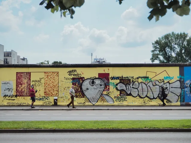
- East Side Gallery
- Brandenburg Gate
- Under the Linden Trees
- DDR Museum
- Kaiser Wilhelm Memorial Church
- Victory Column (Siegessaule)
- Parliament Building
- Memorial to the Murdered Jews of Europe
Show More
The Berlin Wall Memorial celebrates the unification of Germany and the breaking of the wall, which was a symbol of repression of the people of East Germany. The Berlin wall, also known in German as Berliner Mauer, was erected on the night of 13th August 1961 as a physical barrier to divide the West Berlin from East Germany. For the so many years that it stood across, it tore apart people’s lives, separating families, loved ones, friends, and livelihood for so many East Germans who suddenly found themselves incarcerated behind this wall. This wall was created only with one purpose, to keep the East Germans fleeing to the West and was very successful in meeting its objective. The Berlin wall fell on 9th Nov. 1989 after 28 years that it was built, as suddenly as it had come up. A symbol of the existing Cold War between the Soviet lead communism and the Western democratic world, the Iron Curtain fell on this day amidst cheer and celebrations around the world.
The Berlin Wall memorial is the most important of the Berlin historical sites and was inaugurated to commemorate the unification of Germany and is to solemnly remember the so many deaths that occurred here in people’s struggle for liberty. The memorial was created in 1998 by the unified Republic of Germany and the State of Berlin. Located on the Bernauer Straße, the monument includes the Chapel of Reconciliation, the Berlin wall documentation Center, a 60 meter. A portion of the wall as it originally was when the wall fell, a window of remembrance, and a visitor centre.
The memorial can be visited between 8:00- 22:00 hrs, including the open-air exhibition. The visitor centre is open from 10:00-18:00 hrs. Tuesday – Sunday.
Address - Bernauer Strasse 111, 13355 Berlin
A setting for many thrillers and a James Bond spy novel, Checkpoint Charlie is located on Friedrichstraße and Zimmerstraße street corner and is one of the essential Berlin historical sites. It is a former border crossing between the East and West Berlin and a reminder of divided Germany and the Cold war era. The checkpoint still has the original barrier, booth, flags, and sandbags on the site as they were during the Cold War era. This border crossing got its name from the NATO phonetic alphabets – Alpha, Bravo, Charlie. The checkpoint was the third to be opened by the Allies around Berlin and hence was named Checkpoint Charlie. It was one of the most crucial crossing points between the West and East Germany and a site of many historical happenings. In 1961, on 22nd Sept. the Allied border guards were allowed to let entry for registered members of the Allied forces and foreign tourists who could then be granted entry to the East. On October, 22nd the same year, the checkpoint was a scene of a confrontation between the American and Soviet forces with tanks facing and weapons hot against each other. Not just this, but this checkpoint was also a witness of many escape attempts from the East to the West. Many of them were successful, and many of them resulted in deaths.
Today Checkpoint Charlie has an open-air exhibition telling the so many stories of successful and failed attempts of many East Germans along with a commemorative plaque by artist Frank Thiel. There is an informative museum that relives the history of the Berlin wall and the East-West divide for the tourists.
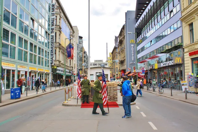
The Checkpoint Charlie is an all-day open venue for tourists. However, the Museum opens daily from 9:00 to 22:00. It remains open even on holidays like Christmas and Easter.
Address – Friedrichstrasse 43-45, 10117 Berlin
Potsdamer Platz started as “Platz von dem Potsdamer Tor” which was a five cornered crossroad in front of one of the 14 city gates - Potsdamer Tor, in Berlin. Post the opening of the Berlin Potsdam railway station in 1838, the place thrived as a major cargo hub and became one of the busiest squares in Europe. Potsdamer Platz saw accelerated growth and development post the foundation of the German Empire in 1871 with many large buildings, hotels, and restaurants coming up on the square. As the rich started settling outside the city gates, the area shot into further prominence and saw a real estate boom. The Palast Hotel and the Grand Hotel Bellevue opened before the end of the century, and the others like Fuerstenhof Hotel and the Esplanade opened a few years later making it the place to be in Berlin. It was the busiest traffic point in Europe with railways and 26 trams and five bus routes going through it. It also has the distinction of having the first traffic light installation in Europe in 1924, which was a landmark in those days.
Potsdamer Platz continuously changed and has been torn down many times to make way for the new. It was destroyed during WWII and became the border triangle marking the Soviet, British and American held sectors after that. Since the coming up of the Berlin wall in 1961, for 28 long years, it was the widest point of Berlin’s death strip or no man’s land and became a massive wasteland in neglect. Post the unification of Germany and the downing of the Berlin Wall, Potsdamer Platz became Europe’s largest construction site in the 1990s with massive modernization and commercial buildings being made. Today one of the essential Berlin historical sites, Potsdamer Platz has transformed into a modern urban landmark with iconic buildings housing world’s leading corporations like Daimler AG, SEB, Bombardier and Bains and Company, etc. and attracting more than 110,000 tourists and visitors every day.
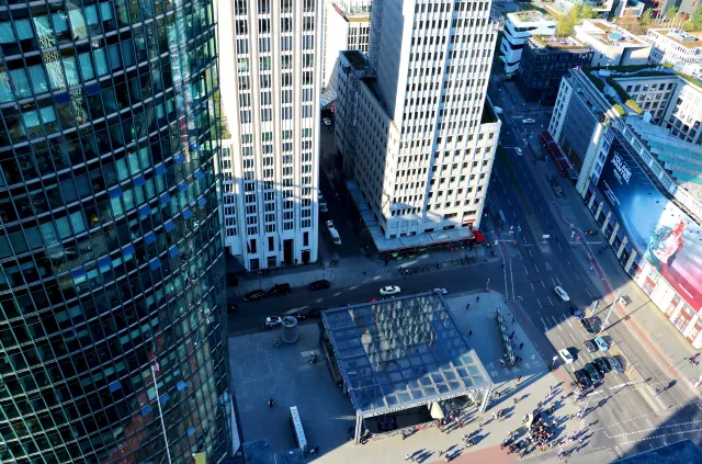
Potsdamer Platz is an open area, and you can visit this place any time without time restriction.
Address - Potsdamer Platz, 10785 Berlin
The Jewish Museum Berlin was opened in 2001. Though the idea to set up the museum was in the works since the breaking down of the Berlin wall in 1989. It was long marred in various disputes which delayed the opening of the same. Initially envisioned to be established as a department of the Berlin Museum, it was later set up as an independent museum foundation under the German federal government. On average, 2000 people have been visiting this museum every day, which is one of the critical Berlin historical sites.
The Museum is developed with a guiding principle of telling stories with its object collections. It has a collection of extraordinary personal items, artworks and relevant documents which shed light on the life of Jews in Germany and the German Jews and has 9500 art words, 1500 religious use objects, 4500 related to culture, 24000 photographs and more than 1,700 individual collections and approximately 11,000 books in the museum library. All of these showcase Jewish history and culture which is a very useful material for research. Most of these artefacts are from the 19th century and early 20th century, providing a good overview of the middle-class Jewish life in the modern age along with their persecution and emigration in Nazi Germany.
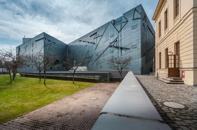
Visiting Hours - Sun-Sat 10:00 AM - 8:00 PM
Address - Lindenstrasse 9-14, 10969 Berlin, Germany
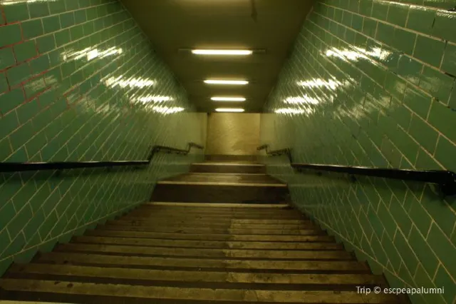
Berliner Underwelten is a unique museum which gives you the view of Berlin’s underground infrastructure and contributes towards preserving it. You will learn about WWII and the Cold War taking a tour of this museum - the city’s hidden.
During WWII, when Nazi Germany began losing to the Allied forces, it started constructing bunkers and tunnels across Berlin and other principle cities across Germany. During the Cold War, these tunnels and bunkers were renovated and even strengthened for preparation of a nuclear conflict between the Super Powers – US and Russia. Millions were spent to construct multi-use buildings that could be used as public utilities as well as for saving lives in case of an attack. You can take a tour where a guide will take you through a maze of underground tunnels and some of the 3000 shelters that are located underground the Berlin city. You will carefully be able to see how people used to live underground during the war and also hear fascinating stories while experiencing the air-raid shelter, a fallout shelter and other underground features that are part of Berlin historical sites.
The ticket office opens daily from 10:00 to 14:00 (check for local holidays and exceptions)
Address - Brunnenstraße, 105.
Tip – If you have claustrophobia, you may want to avoid this place.
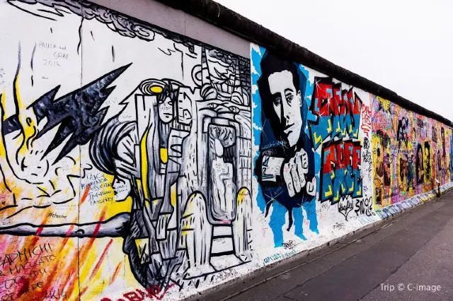
Once a part of the Berlin Wall and now the world’s most extended open-air gallery, the East Side Gallery is a 1. 3 Km. Walk with art and history depicted on the wall all across and is one of the critical Berlin historical sites. One of the essential features of this running art gallery is the painting by Trabant, which shows Brezhnev and Honecker in a socialist kiss. Running along the bank of the Spree in Friedrichshain, this gallery was taken over by 118 artists coming from 21 nations who began painting as the Berlin wall fell. It was officially opened as an art gallery on 28th Sept. 1990 and was declared as a memorial a year later.
The gallery is an open exhibition, and there is no time restriction to visit the place.
Address - Mill Street 3-100, 10243 Berlin
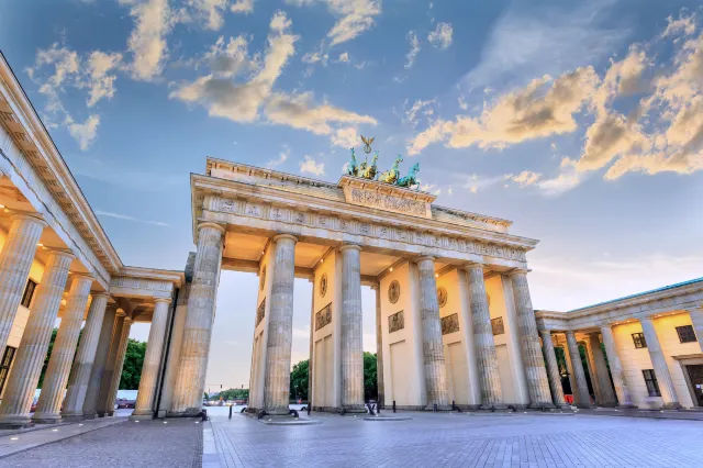
Brandenburg Gate is the last and the only one remaining of the town gates of Berlin in Germany. It is located at the western end of the Unter den Linden avenue. It witnessed the different times where it was both a symbol of Germany’s division as well its unification. It remains one of the most visited Berlin historical sites and a landmark in the city. Frederick William the II constructed it as an entrance gate to Unter den Linden leading to the Prussian palace. This sandstone structure was built between 1788-91 by Carl Langhans and resembled the Propylaea in Athens. The portal is made with 12 Doric columns with five passages with the middle one reserved for royals. It is 20 metres tall, 65 feet wide, and 36 feet in depth. Part of the pavilions was destroyed during WWII and was reconstructed in the 1990s. Decorated with sculptures, a statue of Quadriga, the goddess of victory was added in 1793. The gate was used for Nazi propaganda during Hitler’s reign and was the venue of a parade when Adolf Hitler got in power in 1933. From 1961 to the fall of the Berlin wall in 1989, the Brandenburg Gate was the symbol of divided Germany and its access was cut off access by the Berlin Wall. The gate reopened during the reunification of the East and West Berlin when the German Chancellor Helmut Kohl walked through it to meet his East German counterpart creating a history.
Address - Pariser Platz, 10117 Berlin
Unter den Linden or Under the Linden Tree is a boulevard and is one of the oldest Berlin historical sites. Running east to west and connecting the demolished royal palace site at the Lustgarten, to the Brandenburg Gate and Pariser Platz. On the east, the boulevard crossed the river Spree near the Berlin Cathedral and further connected the Karl-Liebknecht-Straße. There are other significant important buildings lined up on this boulevard as it runs through the heart of the historic Berlin city.
First developed on instructions of the prince-elector of Brandenburg - John George in the 16th century, who needed it to ride his horse to reach his hunting grounds in Tiergarten. Later it was replaced and developed as a boulevard with Linden trees planted all across the path and got extended till the city gates in 1647, under Fredrick William- the Duke of Prussia. In 1851 a statue of Fredric II of Prussia was installed at the centre of the boulevard. It was also made famous in the waltz written by the great music composer of his time – Johann Strauss III, in 1900 who wrote “Unter den Linden”. As Berlin expanded and developed towards the west, Unter den Linden became a grand avenue with many prestigious facades coming up in the 19th century. During the war in 1934-35, most of these trees were cut down or destroyed with the present-day Linden trees replanted in 1950. Today it remains one of the most visited places and finds a special place among various Berlin historical sites.
Address - Unter den Linden, 10117 Berlin
The DDR Museum is located in the centre of Berlin in a former government district of Eastern Germany. It lies on the bank of the river Spree and is opposite the Berlin Cathedral and is one of the essential Berlin historical sites. It is rated as the 11th most visited museums in Berlin. It was opened as a private museum in 2006 with self-funding as against the other state-funded museums. It was nominated for the “European Museum of the Year” award in 2008.
It has an exhibition showcasing the life of people in former East Germany. The museum has three themes and areas designated to it - Public Life, Life in Tower Block and State and Ideology. Each issue showcases the positive and negative side of it. An exciting exhibition that will enlighten you to the way of life that was there behind the Iron Curtain, the DDR Museum is a must-visit place in Berlin.
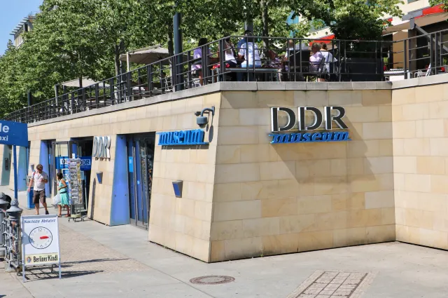
Visiting Hours : Sun - Fri 10:00 AM - 8:00 PM, Sat 10:00 AM - 10:00 PM
Address - Karl-Liebknecht-Str. 1 | Direkt a der Spree, opposite of Berliner Dom, 10178 Berlin, Germany
Kaiser Wilhelm Memorial Church is one of the well-known Berlin historical sites and is popularly known as Gedächtniskirche. Berliners also refer to this church as "der hole Zahn", which means, the hollow tooth. The brain behind this Protestant church was Kaiser Wilhelm II. His main objective was to take the country back to its traditional values as opposed to the socialist movement that was gaining momentum those days. Wilhelm II named the church after his grandfather, Kaiser Wilhelm I, and laid the foundation stone on his birthday, 22nd March, in 1891. The construction, which was mainly funded through donations, cost a whopping 6.8 million German gold mark. The credit for the church design goes to Franz Schwechten, the architect who designed the Anhalter Bahnhof. The church which can seat around 2000 people was finally dedicated on 1st September 1895. The mosaics in the church take you through the different periods of Germany. It is like taking a walk through German history books.
An air raid carried out in 1943 severely damaged the old church. The church was rebuilt in the late 1950s. The new church was consecrated on December 17th, 1961. Parts of the early church were retained with the ground floor converted as a memorial hall and the vestibule into a memorial of the war.
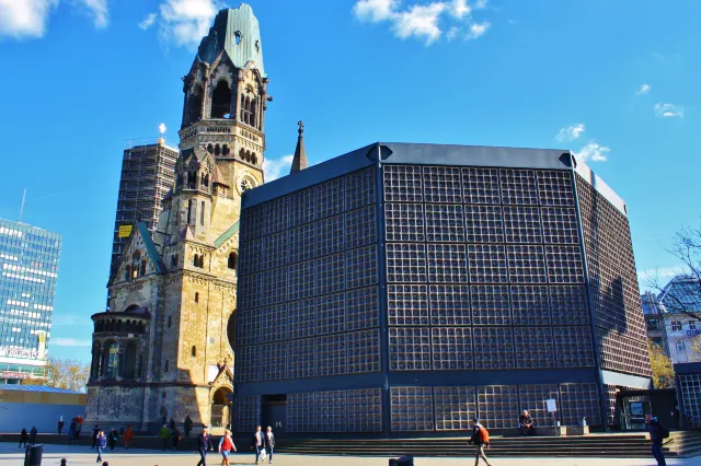
Open: Monday to Saturday: 10 a.m. to 6 p.m. Sunday: 12 a.m. to 5:30 p.m.
Address: Kaiser Wilhelm Memorial Church, Breitscheidplatz, 10789 Berlin, Germany.
The Victory Colum, also known as Suegessaule is a monument in Berlin that was designed and constructed in 1873 by Heinrich Strack to commemorate the victory in the Danish Prussian war. The colossal bronze sculpture of “Victoria” measures eight meters. And weighs 35 tons and was relocated by the Nazis in 1930 to the middle of the Tiergarten park in Berlin where it stands today. The structure itself is 67 meters. Tall and provides a magnificent view from the top. An icon in Berlin, this monument is a must-visit among the other Berlin historical sites.
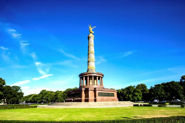
Address - Grosser Stern 1, 10557 Berlin, Germany
The Reichstag or the Parliament building is one of the essential Berlin Historical sites. It was constructed to house the Diet which was the imperial council of reigning princes of the German states. It was used from 1897 to 1933 when it was severely damaged on being set on fire. It fell neglected and unused after WWII. The building was recreated in 1999 to house the German parliament after a massive reconstruction. It is now the 2nd most visited tourist place in Germany. The large glass dome on top was recreated and built to give an impressive 360-degree view of the city and is open to tourists by prior registration.
Entry Timing: Roof terrace and dome: 8:00-24:00 The latest entry is 22:00. It remains closed on December 24th and the closing time is 16:00 on December 31st.
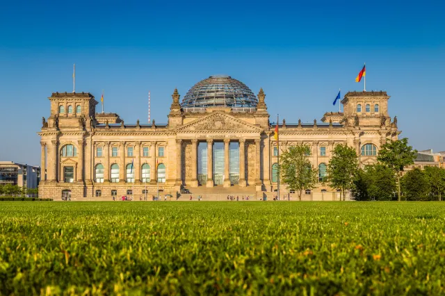
Address - Republic Square 1,11011 Berlin
The Memorial to the Murdered Jews of Europe, also known as the Holocaust Memorial is a 19,000 sq. Metre. The Site covered with 2,711 slabs in a grid pattern resembling a cemetery. An underground information place lists the names of the 3 million Jews who died in the holocaust. This museum was opened to the public on 10th May 2005 and was constructed at the cost of €25 million and lies close to the Brandenburg gate and is among the main Berlin historical sites.
Information Center opening hours: April-September Tuesday-Sunday 10:00-20:00 (final entry 19:15), October-March March-Sunday 10:00-19:00 (last Enter 18:15). It is closed every Monday, December 24-26, and January 1. It closes at 16:00 on December 31st.
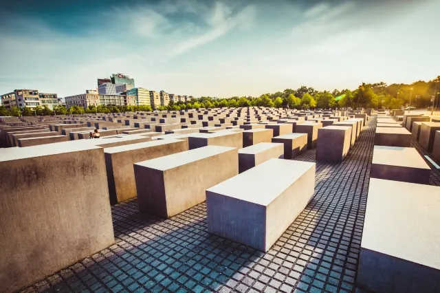
Address - Cora-Berliner-Strasse 1, 10117 Berlin


Trending Travelogues
Popular Trip Moments
Popular Travel Types
Popular Attractions
Popular Ranked Lists
Popular Destinations
Recommended Attractions at Popular Destinations


About


Site Operator: Trip.com Travel Singapore Pte. Ltd.