


1 / 10

Mentioned in This Moment
4.3/578 reviews | Mountains
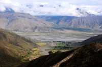
Dangxiong
View
Show More
2023 Tibet Self-Drive Tour—Day 21 Namtso
KALLIE BLAKE
The winter Namtso can heal everything!
SIMONE STEWART
Winter at Namtso
AMBROSE SOTO
Nam Co | The Healing Blue Series, life is worth it!
ANDERSON CHAPMAN
Winter in Tibet | It's such a pity you haven't been to Namtso
Olivia.Simmons.78

Chaqucuo | The surprise is around the next corner
Aiden.Peterson@84
After a 4-day journey on the Yunnan-Tibet Highway—from Lhasa to Lijiang
Jasper Considine DVM
Popular Trip Moments
You don't have to go to Nyingchi, there is also a paradise of peach blossoms in eastern Tibet, with fewer people and more beautiful scenery | Day 8 in the collection | If heaven has a form, it must look like the Holy Elephant Gate! | Chaqucuo | The surprise is around the next corner | The gods and humans dwell together in Bingzhongluo | Bamuco | Dreamy blue lake | Dangre Yongcuo | The lake also has a "dopamine outfit" | The off-the-beaten-path glacier you've never been to | 2024 Tibet North Ring Line: Step into the Bogda Glacier | 【Annual Review】Do you know these niche attractions in Nagqu, Tibet? | The highest city - Nagqu | Seeing a topic, why must we go to Tibet in this lifetime? | Tibet·Tanggula Mountain·Scenery on the road | Serling Tso | The largest devil lake in Tibet | Sichuan Yunnan Tibet Xinjiang Gansu Qinghai Sichuan | 2023-10-05 Sichuan Yunnan Tibet Xinjiang Gansu Qinghai | The small county town by the Nujiang River, with a vast territory, the snow mountain scenery is unforgettable | Half snow and half lake, it's so beautiful that it's intoxicating! | Kangqingla Mountain Pass, thinking of her at a considerable height
Popular Destinations
Chicago Travel | Toronto Travel | Kaohsiung Travel | Zhengzhou Travel | Chongqing Travel | Mt Hood Village Travel | Guatemala City Travel | Wilmington Island Travel | Stockbridge Travel | Illinois Travel | Huai Yai Travel | Koh Samui Travel | Caticlan Travel | Tucumcari Travel | Arcata Travel | Lisbon Travel | St. Petersburg Travel | Taunggyi Travel | Butuan Travel | Central Tigray Travel | North Western Province Travel | Tracy Travel | Itami Travel | Sennen Travel | Reading Travel | Exmoor National Park Travel | Qijiang District Travel | Fingal Travel | Argeles-sur-Mer Travel
Recommended Attractions at Popular Destinations
Bangkok attraction near me | Tokyo attraction near me | Manila attraction near me | Hong Kong attraction near me | Taipei attraction near me | Seoul attraction near me | Los Angeles attraction near me | New York attraction near me | Shanghai attraction near me | Kuala Lumpur attraction near me | Shenzhen attraction near me | Osaka attraction near me | Singapore attraction near me | Guangzhou attraction near me | London attraction near me | San Francisco attraction near me | Beijing attraction near me | Macau attraction near me | Bali attraction near me | Paris attraction near me | Ho Chi Minh City attraction near me | Orlando attraction near me | Jakarta attraction near me | Chicago attraction near me | Phuket attraction near me | Toronto attraction near me | Istanbul attraction near me | Dallas attraction near me | Cebu attraction near me | Seattle attraction near me
Popular Attractions
The Grand Palace | Yves Saint Laurent Mansion | Yokohama Hakkeijima Sea Paradise | Miniatur Wunderland | Ocean Park Hong Kong | Universal Beijing Resort | Kuala Lumpur Tower | Carnival Magic Phuket | American Museum of Natural History | Tokyo Skytree | Phuket Aquarium | Golden Gate Bridge | Ghibli Museum | Spyscape | Huangpu River Tour(16 Pu Pier) | Shanghai Ocean Aquarium | Methanam Juma Masjid | Mirador | Fountain Hills Desert Botanical Garden | Notre-Dame de la Couture | Château de Sommieres du Clain | All-In | Periyandavar Temple. பெரியாண்டவர் கோவில் | Carrara Fiere | Ruta de las Foces del Esva (Salida El Suco - Bustiello) | Woollen’s Garden | Mirror Maze | Chengdu Research Base of Giant Panda Breeding | The Huntington Library, Art Museum, and Botanical Gardens | The Metropolitan Museum of Art
Popular Restaurants in Naqu
Jiayuguanyiliasi Barbecue | 马占海烤肉城第二分店(藏北酒店店) | 安多蜀都川菜食府(沈阳北路店) | 南充米粉(恰青路店) | KAO FAN TIAN SHUAN KAO WU | 琼五美食城 | 格尔木烤羊肉串(安多店) | 川味一品香饭店 | 甜城小吃(双湖店) | 川味美食 | 次仁茶馆 | Yifayuanlanzhou Lamian Noodles | 兰瑞饭店 | PIN SHANG PIN GA FEI | 雅安饭店(吉江扎西南路店) | 成都新派川菜 | 神山兄弟酒吧 | 七椒渔府(文化中路店) | 双湖幺妹川菜馆(色卓路店) | 泰和轩川菜酒楼 | 老柴房柴火鸡 | 一品香饭店(班戈店) | 开门红酒楼 | 崃山饭店(绍兴北路店) | Yunnanguoqiao Rice Noodles | 伊沁老炒面片 | 德克士(浙江商城店) | MEI SHI LE | ZHI WEI XUAN CHUAN CAI GUAN | 兰州正宗牛肉拉面(比如店)
Popular Ranked Lists
Popular Nightlife Districts in Kaohsiung | Popular Family-friendly Attractions Near Tuokexun | Popular Luxury Hotels Near Tourrettes-sur-Loup | Popular Family-friendly Attractions Near Zhidan | Popular Premium Hotels in Araches-la-Frasse | Popular Luxury Hotels Near Kagoshima | Top 6 Bars in Dublin | Top 5 Bars in Prague | Popular Nightlife Districts in Hong Kong | Top 4 Bars in Semporna | Top 10 Clubs in Tbilisi | Popular Premium Hotels in Satellite Town Jhelum | Top 10 Bars in Auckland | Popular Premium Hotels in Kaluga | Popular Family-friendly Attractions Near Jingzhou | Top 7 Fine Dining in Dalian | Popular Premium Hotels in Anning | Top 9 Bars in Brussels | Popular Luxury Hotels Near Foxborough | Popular Nightlife Districts in Lijiang | Popular Nightlife Districts in Pattaya | Popular Nightlife Districts in Dublin | Popular Nightlife Districts in Taipei | Popular Nightlife Districts in Jinghong | Popular Nightlife Districts in Las Vegas | Popular Nightlife Districts in Shanghai | Popular Nightlife Districts in London | Popular Nightlife Districts in Seoul | Popular Nightlife Districts in Beijing | Popular Nightlife Districts in Chengdu
About
Payment Methods
Our Partners
Copyright © 2024 Trip.com Travel Singapore Pte. Ltd. All rights reserved
Site Operator: Trip.com Travel Singapore Pte. Ltd.
Site Operator: Trip.com Travel Singapore Pte. Ltd.